
Mount Eden (volcano)
| Mount Eden | ||
|---|---|---|
 Mount Eden above the Auckland suburb of Epsom |
||
| height | 196 m | |
| location | Auckland , New Zealand | |
| Coordinates | 36 ° 52 '37 " S , 174 ° 45' 50" O | |
|
||
| Type | volcano | |
| Normal way | Puhi Huia Road | |
| particularities | Highest point in Auckland | |

Mount Eden ( Māori : Maungawhau , "Mountain of the Whau Tree") is the name of a cinder cone in Auckland City on the North Island of New Zealand . The mountain is located about five kilometers south of the city center and is surrounded by the suburb of Mount Eden . The mountain is the highest natural elevation in Auckland. It got its English name in honor of George Eden, 1st Earl of Auckland .
geography
Mount Eden is a dormant volcano belonging to the Auckland Volcanic Field , in the 196 meter high summit of which there is a 50 meter deep grassy crater. The mountain consists of three individual craters arranged in a row, which give it an oval shape.
The last eruption occurred 28,000 years ago from two craters, with the last eruptions from the southern crater filling the northern crater. Basaltic lava from the crater covered an area of 5.6 km². A total of 162 million cubic meters of lava was ejected. These form thicker deposits, particularly in the direction of the Kyber Pass and Newmarket.
Since the entire volcanic field consists predominantly of volcanoes formed by individual events, a new eruption is considered unlikely. The mountain is protected by the city under the Auckland City Isthmus District Plan because of its archaeological and geological importance .
Before the arrival of Europeans, the mountain was for about 800 years from several iwi of Māori inhabited and as Pā used (fortified settlement). The mountain was one of the most important Māori settlement centers in the Auckland area. The settlement ended in 1700 when the Waiohua defeated the Tamaki . Earth walls and terraces and the remains of living spaces and storage pits from this period are still visible today. The Māori saw the eating bowl of the god Mataahou ( Te Ipu a Mataahou ) in the crater .
In 1840 the summit was one of the three points that marked the land acquired for Auckland. There is still a trigonometric point on the summit today .
From 1877 water reservoirs were created on the mountain. The rainwater quickly seeps into the porous volcanic rock of the mountain and emerges as a lake near Western Springs . between 1877 and 1910 this was one of the first public Auckland water reservoirs.
Mount Eden's lava flows were mined in several quarries, the last of which closed in 1928. Below that are the fractions that are below the Auckland Grammar School . The material for most of the curbs on the Auckland streets comes from here, as does the stone used to build some older buildings.
From the 1950s the New Zealand Post Office used the summit for VHF radio. There were two buildings several hundred meters apart with their own antenna farm. The transmitter was in one of the buildings, the receiver in the other. In the 1960s, the plant was manned by maintenance personnel during the week. It was mainly used for taxi radio and other companies that need vehicle communication.
Mount Eden is accessed via the narrow Puhi Huia Road, and there is a parking lot near the summit. The road has been closed to buses since 2011 and to all other motorized traffic since 2016 in order to protect the archaeological sites on the mountain and to respect its spiritual significance for the Māori .

Behind Mount Eden (left) Alexandra Park from One Tree Hill taken from
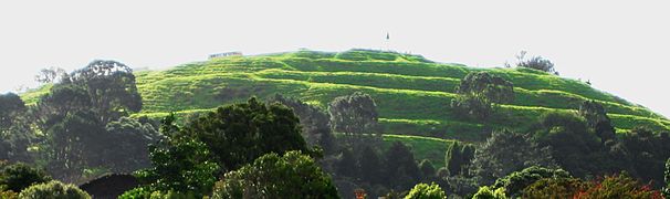
Terraces on the south slope of Mount Eden

Mount Eden behind the city center, view from Northcote.

Mount Eden crater


See also
literature
- The Lively Capital, Auckland 1840-1865 . Una Platts. Avon Fine Prints Limited New Zealand 1971.
- Colonial Architecture In New Zealand . John Stacpoole. AH & AW Reed 1976.
- The Changing Face Of Mount Eden . Faye M. Angelo. Mount Eden Borough Council 1989.
- Volcanoes of Auckland: The Essential Guide - Hayward, BW, Murdoch, G., Maitland, G .; Auckland University Press, 2011.
Web links
- Auckland Volcanic Field Geology . GNS Science, January 25, 2010,accessed February 7, 2016.
Individual evidence
- ^ Richard Smith, David J. Lowe, Ian Wright: Volcanoes - Mt Eden. In: Te Ara Encyclopedia of New Zealand . November 5, 2007, accessed May 16, 2009 .
- ↑ Maungawhau-Mt Eden Management Plan . (PDF 2.8 MB) Auckland City Council , February 2007, archived from the original ; accessed on February 7, 2016 (English, original website no longer available).
- ^ What's Doing In; Auckland - The New York Times , February 18, 2001
- ↑ Rawiri Taonui : Tāmaki tribes - Tribal history and places . In: Te Ara - the Encyclopedia of New Zealand . Ministry for Culture & Heritage , September 22, 2012, accessed February 7, 2016 .