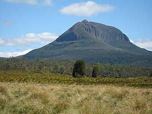
Mount Pelion West
| Mount Pelion West | ||
|---|---|---|
|
Mount Pelion West from the Pelion Hut on the Pelion Plains |
||
| height | 1560 m | |
| location | Tasmania | |
| Mountains | Pelion Range | |
| Coordinates | 41 ° 49 '54 " S , 145 ° 58' 39" E | |
|
|
||
| rock | Diabase | |
| Age of the rock | law | |
| First ascent | January 30, 1946 | |
| Normal way | from the Pelion Hut in 1 day | |
| particularities | Third highest peak in Tasmania | |
The Mount Pelion West is a mountain in the center of the Australian state of Tasmania . It is located in the center of the Cradle Mountain Lake St. Clair National Park and on the eastern edge of the catchment area of the Murchison River . At 1,560 m, it is the third highest mountain in Tasmania and thus one of only 8 peaks over 1,500 m.
location
The network coordinates in the UTM coordinate system are 152682 UTM Zone 55S, and a high-resolution topographic map (1: 25,000) is available from Tasmap (No. 4036). To the west lies extensive, relatively flat grassland, to the north of Cradle Mountain and Barn Bluff , to the northeast of Mount Oakleigh , to the east of Mount Pelion East and immediately afterwards to the south of Mount Achilles . At the north foot of the mountain, the Pelion Creek flows, which flows into the upper reaches of the Forth River . The Forth River rises immediately east of Mount Pelion West in the Frog Flats (720 m), the lowest point of the entire Overland Track . This long-distance hiking trail passes Mount Pelion West at a distance of 2 km.
history
The hiker and mountaineer Keith Ernest Lancaster (1910-2003) climbed Mount Pelion West on January 30, 1946 after a slow and tormenting walk (on all fours) through thorn bushes ( Richea scoparia ), which is often found in the alpine region around the mountains Tasmania finds. Lancaster named Mount Pelion West as one of the Giants of the Reserve . In his report on the ascent, he mentioned "the tangle of enormous boulders" in the summit region.
Ascent
The Tasmap map shows the approximate location of the hiking trail on which you climb the mountain via its northeast spur. The unmarked trail begins about 250 meters east of the Overland Track bridge over Pelion Creek and climbs between two tree trunks hanging over the track. The mountain is much more difficult to climb than Mount Pelion East or Mount Ossa , the other two popular detours from the 65 km long Overland Track. Above all, this is due to the difficult, 500 m long traverse through huge diabase rock blocks to reach the obelisk-like summit structure.
Web links
- LISTmap (Mount Pelion West) . Tasmanian Government Department of Primary Industries and Water. Retrieved January 14, 2008.
Individual evidence
- ^ Height of major Mountains, Tasmania . Australian Bureau of Statistics
- ^ The Overland Track . Tasmania Parks & Wildlife Service


