
Mount Royal Range
| Mount Royal Range | ||
|---|---|---|
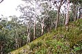
 The Mount Royal from Mount Cabrebald from Barrington Tops National Park |
||
| Highest peak | Brumlow Tops ( 1586 m ) | |
| location | New South Wales | |
|
||
| Coordinates | 31 ° 50 ′ S , 151 ° 29 ′ E | |
| rock | volcanic origin | |

The Mount Royal Range is a mountainous country in New South Wales , Australia , an area in the Hunter River Region about 90 km from Newcastle .
history
The mountains of the Mount Royal Range are of volcanic origin . They were the traditional field of Aborigines of Biripi, Worimi, Geawegal, Wonaruah and Ungooroo who have been displaced by the Europeans during the colonization. Mount Mackenzie was the site of a violent clash between Europeans and Aborigines.
European settlement in the 18th century was promoted by the development of timber and livestock farming and gold discoveries. In the 20th century the area was first in search of recreation, in the 1920s and 1930s tourism began to develop in the Barrington Tops and during World War II there were protests against further economic development and against road construction in the mountain area. The first efforts to establish a national park were made in the 1950s. As a result, two small nature reserves were established at Gloucester Tops and in the Williams River area . In 1969 the Barrington Tops National Park was founded .
location
The Mount Royal Range is on the east side of the Great Dividing Range . The mountain area is drained by the Hunter River and Manning River , which flow towards the east coast of New South Wales . The height differences in the mountain area are considerable and range from 200 to 1586 meters. The Barrington Plateau separates the catchment area of the upper Hunter River and its tributaries from the catchment area to the east. To secure the water supply for the Bayswater power station , the Barnard River Scheme was built in the 1980s to supply water to the Hunter River.
The Mount Royal Range forms the northern edge of the Hunter Valley . The Barrington Tops , a high plateau at the upper waters of the Barrington River , are part of the Mount Royal Range , as well as the Mount Royal National Park and Barrington Tops National Park , both as the UNESCO - World Heritage listed. With the Barrington Tops State Conservation Area , three protected areas are combined into one planning area.
mountains
The highest mountain in the Mount Royal Range is the Brumlow Tops with 1586 meters, other mountains are Gulph Mountain, Gog and Magog, The Pinnacle, Paddy's Ridge, Mount William, Mount Paterson, Mount Allyn, Mount Royal , Mount Toonumbue, Belgrave Pinnacle, Mirannie Mountain, Mount George, Hudson's Peak and Mount Johnstone. The name of the mountain region is based on Mount Royal, the most famous of the mountains there.
Mount Royal - eucalyptic forest

Mount Royal, basalt at an altitude of 1100 meters

Mount Royal - Rainforest , Mosses and Ferns

Snow eucalyptus on the summit of Brumlow Tops (1585 m)


Individual evidence
- ↑ environment.nsw.gov.au (PDF; 3.8 MB): Barrington Tops National Park, Mount Royal National Park, and Barrington Tops State Conservation Area. Plan of Management , p. 4, accessed February 5, 2012
- ↑ a b environment.nsw.gov.au (PDF; 3.8 MB): arrington Tops National Park, Mount Royal National Park, and Barrington Tops State Conservation Area. Plan of Management , p. 7, accessed February 5, 2012
- ↑ environment.nsw.gov.au : Manning River. Water Quality and River Flow Objectives , accessed February 5, 2012
- ↑ abs.gov.au : Mountains Systems (Orography) of Australia , in English, accessed February 5, 2012