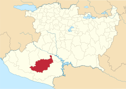
Municipio Tumbiscatío
| Tumbiscatío | |
|---|---|

|
|
| Basic data | |
| Country | Mexico |
| State | Michoacan |
| Seat | Tumbiscatío de Ruiz |
| surface | 2,068.8 km² |
| Residents | 8363 (2010) |
| density | 4.04 inhabitants per km² |
| founding | 1955 |
| Website | tumbiscatio.gob.mx |
| INEGI no. | 16096 |
| politics | |
| Presidente municipal | Febronio García Aguilera |
Coordinates: 18 ° 31 ′ N , 102 ° 30 ′ W
Tumbiscatío is a municipality in the Mexican state of Michoacán in the Sierra-Costa region . The municipality had 8363 inhabitants at the 2010 census; the area of the municipality is 2068.8 km². The largest place in the municipality and administrative seat is Tumbiscatío de Ruiz .
geography
The municipality of Tumbiscatío is located in the south of the Mexican state Michoacán at heights between 300 m and 2300 m in the Sierra-Costa region . It is entirely in the physiographic province of the Sierra Madre del Sur , two thirds in the hydrological region of Costa de Michoacán and one third in the hydrological region of Balsas . The geology of the Municipalities is 47% of metamorphic determined at 15% sandstone - conglomerate and 10% andesite - Tuff ; the predominant soil types are Luvisol (62%), Phaeozem (16%) and Cambisol (11%). About 90% of the community area is forested, about 5% is used as pastureland.
The municipality of Tumbiscatío borders on the municipalities of La Huacana , Aguililla , Apatzingán , Coalcomán de Vázquez Pallares and Arteaga .
population
In the 2010 census, 7890 people were counted in 1798 residential units in the municipality. Of these, 14 people were registered as speakers of an indigenous language . Almost 24 percent of the population were illiterate. 2428 inhabitants were registered as economically active, of which approx. 86% were men or 1.2% were unemployed. 40% of the population lived in extreme poverty.
places
The Municipio Tumbiscatío comprises 185 inhabited localidades , of which only the main town is classified as urban by the INEGI . Two of the places had a population of over 1000 in the 2010 census, 178 places had fewer than 100 inhabitants. The biggest places are:
| place | Residents |
| Tumbiscatío de Ruiz | 2801 |
| General Francisco Villa ( Las Cruces ) | 1298 |
| Potrerillos de Coria ( La Loma ) | 423 |
Web links
- Enciclopedia de los Municipios y Delegaciones de México: Municipio Tumbiscatío (Spanish)
- INEGI : Datos Geográficos: Municipio Tumbiscatío (Spanish; PDF)
