Municipio Urmiri
| Municipio Urmiri | ||
|---|---|---|
| Basic data
|
||
| Population (state) - population density |
2759 inhabitants (2012 census) 2 inhabitants / km² |
|
| Post Code | 05-0104 | |
| Telephone code | (+591) | |
| surface | 1,323 km² | |
| height | 4400 m | |
| Coordinates | 19 ° 30 ′ S , 66 ° 10 ′ W | |
|
|
||
| politics
|
||
| Department | Potosí | |
| province | Tomás Frías Province | |
| Central place | Urmiri | |
 Location of the Municipio Urmiri in the Department of Potosí |
||
| climate | ||
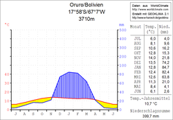
 Oruro climate diagram |
||
The Municipio Urmiri (also: Belén de Urmiri ) is a district in the Potosí Department in the highlands of the South American Andean state of Bolivia .
Location in the vicinity
The Municipio Urmiri is one of four Municipios in the Tomás Frías Province . It borders the Municipio Yocalla to the east, the province of Antonio Quijarro to the south, the Oruro department to the northwest , and the Tinguipaya municipality to the northeast .
geography
The Municipio Urmiri covers a 1,300 km² barely populated plateau between the city of Potosí in the south-east and Lake Poopó in the north-west, which is cut by numerous rivers. Temperatures are close to the frost line throughout the year during the day , significant precipitation only falls in the summer months, so that many of the rivers are largely dry in winter.
population
The population of the Municipio Urmiri has almost doubled over the past two decades:
- 1992 : 1,521 inhabitants ( census )
- 2001 : 2,025 inhabitants (census)
- 2012 : 2,759 inhabitants (census)
The life expectancy of newborns is 53 years, the literacy rate for those over 15 years of age is 68 percent, and the proportion of the urban population in the municipality is 0 percent. ( 2001 )
The municipality comprises a total of 37 localities, the central place of the district is Urmiri with 839 inhabitants ( 2012 ) in the northeast part of the district.
politics
Results of the elections for the municipal council ( concejales del municipio ) in the regional elections on April 4, 2010:
| electoral legitimate |
electoral participation |
valid votes | MAS-IPSP | ||
|---|---|---|---|---|---|
| 856 | 734 | 493 | 493 | ||
| 85.7% | 67.2% | 100.0% |
structure
The municipality is divided into the following two cantons ( cantones ):
- 05-0104-01 Canton Urmiri in the central and south-eastern part - 31 villages - 2,223 inhabitants
- 05-0104-02 Canton Cahuayo in the north-western part - 6 localities - 536 inhabitants
Localities in the municipality of Urmiri
- Urmiri Canton
- Urmiri 839 pop - Vacuyo Andamarca 554 pop
Individual evidence
- ↑ Instituto Nacional de Estadística (INE) 1992
- ^ Instituto Nacional de Estadística (INE) 2001
- ↑ Instituto Nacional de Estadística (INE) 2012 ( Memento of the original of July 22, 2011 in the Internet Archive ) Info: The archive link has been inserted automatically and has not yet been checked. Please check the original and archive link according to the instructions and then remove this notice.
- ↑ Acta de computo Nacional Electoral Departamentales, Municipales y Regional 2010
Web links
- Municipio Urmiri - General Maps No. 50104
- Municipio Urmiri - detailed map and population data (PDF; 612 kB) ( Spanish )
- Department Potosí - social data of the municipalities (PDF; 5.23 MB) ( Spanish )
