
Murg (Aare)
| Murg | ||
_029.jpg) The Murg from the bridge connecting Murgenthal and Wynau seen from |
||
| Data | ||
| Water code | CH : 497 | |
| location |
Mittelland
|
|
| River system | Rhine | |
| Drain over | Aare → Rhine → North Sea | |
| origin | Confluence of the Rot and Langete 47 ° 15 ′ 4 ″ N , 7 ° 49 ′ 35 ″ E |
|
| Source height | 420 m | |
| muzzle | near Murgenthal in the Aare Coordinates: 47 ° 15 '55 " N , 7 ° 49' 31" E ; CH1903: 629 267 / 234 988 47 ° 15 '55 " N , 7 ° 49' 31" O |
|
| Mouth height | 400 m | |
| Height difference | 20 m | |
| Bottom slope | 8.3 ‰ | |
| length | 2.4 km | |
| Catchment area | 184.82 km² | |
| Discharge at the Murgenthal gauge , Walliswil A Eo : 183 km² Location: 2.2 km above the mouth |
NNQ (1991) MNQ 1981–2016 MQ 1981–2016 Mq 1981–2016 MHQ 1981–2016 HHQ (1986) |
850 l / s 2.28 m³ / s 3.5 m³ / s 19.1 l / (s km²) 4.95 m³ / s 50.2 m³ / s |
| Discharge A Eo : 185 km² at the mouth |
MQ Mq |
3.47 m³ / s 18.8 l / (s km²) |
The Murg is a right and southern tributary of the Aare . Together with its source river Langete , it has a length of about thirty-four kilometers. Over its entire length of 2.4 kilometers, it forms the border between the cantons of Bern and Aargau .
geography
Source rivers
The Murg arises east of Wynau at an altitude of 420 m above sea level. M. from the confluence of the Langete with the Rot .

|

|
|
|
The Langete
|
The Red
|
Langete
The 31 km long Langete is the left, southwestern source river.
It has a catchment area of 131.43 km² and a mean discharge ( MQ ) of 2.55 m³ / s.
red
The 17 km long Rot is the right and south-southeastern source river.
It has a catchment area of 46.07 km² and a mean discharge (MQ) of 0.79 m³ / s.
course
After the confluence, the Murg initially flows north-northwest in a wide arc through natural meadows, where it is fed by the Brunnbach on its left side. South of Guegiloch , it takes the water from a right fork in the Mürli stream from the left . About 150 m downstream, the Stampfibach flows into the Murg from the right . Immediately afterwards the Rotkanal branches off on the same side. The Murg now meanders in dense woodland and is accompanied by the Red Canal on the right and the tracks of the regional trains on the Olten-Langenthal route on the left in a northerly direction through fields and meadows.
To the northwest of Trottenhubel, the river is bridged by the new Mattstetten – Rothrist line . A little later it crosses the railway system, flows past extensively used meadows and pastures as well as high-stemmed field fruit trees and then reaches the locality of the Wynau district of Obermurgenthal and the city of Murgenthal . Fruit is grown there on the right.
The Murg still crosses under Hauptstrasse 1 , then runs to the left past Heimweiden and to the right past hedges, field and bank trees with herb edges and finally flows east to a wastewater treatment plant (ARA) at an altitude of 400 m above sea level. M. from the right and south into the Aare approaching from the west .
- River impressions

The Murg near Aegerten

The Murg near Aegerten

The Murg above Murgenthal

The Murg, between Murgenthal and Wynau

Murg influx into the Aare
.jpg)


_026.jpg)

Catchment area
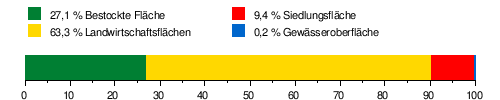
The 184.82 km² catchment area of the Murg lies in the Swiss Plateau and is drained to the North Sea via the Aare and the Rhine .
It consists of 27.1% wooded area , 63.3% agricultural area , 9.4% settlement area and 0.2% water area.
Area distribution
The mean height of the catchment area is 651 m above sea level. M. , the minimum height is 399 m above sea level. M. and the maximum height at 1115 m above sea level. M.
Tributaries and branches
- Langete ( left source river ), 31.0 km, 131.00 km², 2.55 m³ / s
- Red ( right source river ), 17.0 km, 46.07 km², 0.79 m³ / s
- Brunnbach ( left )
- Stampfibach ( right )
- Rothbach Canal ( right junction ), 8.5 km
- Mürlibach ( left )
- Garbage canal ( left )
Red channel

Shortly after the confluence of the Rot and Langete, the 8.5 km long Rotkanal branches off, which runs parallel to the Aare to Rothrist . It was created around 1640 for the purpose of irrigation of the so-called "Hungerzelg" and was maintained from then until 1999 by the "Rothbachwässerungsgenossenschaft".
Since 1856 the canal has also been used to generate hydropower, initially for industrial companies and since 1943 for a small power station.
Hydrology
At the confluence of the Murg and the Aare, the modeled mean discharge rate (MQ) is 3.47 m³ / s. Her discharge regime type is pluvial inférieur and her discharge variability is 25.

Namesake
The municipality of Murgenthal takes its name from the river.
See also
Web links
Individual evidence
- ↑ a b Geoserver of the Swiss Federal Administration ( information )
- ↑ Water network in the WebGis geographic information system of the canton of Bern
- ↑ a b Topographical catchment areas of Swiss waters: area outlets. Retrieved May 26, 2019 .
- ↑ Murgenthal measuring station, Walliswil 1981–2016 (PDF) Federal Office for the Environment FOEN
- ↑ a b Topographical catchment areas of Swiss waters: Murg
- ↑ Empties into the Aare
- ↑ Left junction, flows back into the Murg
- ↑ W. Jäggi: The red channel. A body of water in the western corner of the canton of Aargau. In: Jahrbuch des Oberaargaus No. 31, 1988, pp. 107-114.
- ↑ "Hidden behind the mean values" - the variability of the discharge regime , p. 7
- ↑ The discharge variability describes the extent of the fluctuations in the mean discharge of individual years around the long-term mean discharge value.