
Nathan Road
| Nathan Road 彌敦道
|
|
|---|---|
|
|
|
 |
|
| Basic data | |
| place | Hong Kong |
| District | Kowloon |
| Created | 1861 |
| Hist. Names | Robinson Road |
| Name received | 1909 |
| Buildings |
The Peninsula Kowloon Mosque , Chungking Mansions |
| MTR |
Tsuen Wan Line : - Sham Shui Po - Prince Edward - Mongkok - Yaumatei - Jordan - Tsim Sha Tsui Kwun Tong Line : - Prince Edward - Mongkok - Yaumatei |
| Technical specifications | |
| Street length | 3.6 km |
The Nathan Road ( Chinese 彌敦道 / 弥敦道 , Pinyin Midun Dào , Jyutping Nei 4 Deon 1 Dou 6 , Yale Nei 4 deun 1 Dou 6 , IPA (Cantonese) [Nȅitɵn TOU] ) is the main road in the district of Kowloon in Hong Kong . It leads in a south-north direction from Tsim Sha Tsui to Sham Shui Po and also crosses the former districts of Yau Ma Tei and Mong Kok.
The road is about 3.6 km long. It begins in the south at Victoria Harbor and ends in the north at Boundary Street ( 界限 街 , Jièxiàn Jiē , Jyutping Gaai 3 haan 6 Gaai 1 ). The six-lane Nathan Road forms the main road connection between the two regions of Kowloon and the New Territories . It is lined with hotels, banks, shops and shopping centers.
history
The first section of the road was completed in 1861. It was the first road built in Kowloon after the Beijing Convention , the cession of land to Great Britain by the Qing Dynasty , in 1860.
The original name of the street was Robinson Road ( 羅 便 臣 道 / 罗 便 臣 道 , Luóbiànchén Dào , Jyutping Lo 4 am 6 san 4 Dou 6 ), named after Sir Hercules Robinson ( 夏喬士 · 羅 便 臣 / 夏乔士 ·罗 便 臣 ), the 5th Governor of Hong Kong . To avoid confusion with Robinson Road on Hong Kong Island , the road was named after Sir Matthew Nathan ( 馬太 · 彌 敦 / 马太 · 弥 敦 ), the 13th governor, who served from 1904 to 1907, in 1909 Renamed "Nathan Road".
Nathan Road was originally a residential street with colonial buildings and the location of the barracks settlement Whitfield Barracks ( 威菲 路 軍營 or 威菲 路 兵 房 ), where Kowloon Park is now. On the road there was also Saint Andrew's Church, completed in 1906 ( 聖安德烈 堂 / 圣安德烈 堂 , Shèng Āndéliè Táng , Jyutping Sing 3 On 1 dak 1 lit 6 Tong 4 ), the oldest church of the Anglican church community in Kowloon .
The section from Gascoigne Road to Argyle Street was originally called Coronation Road ( 加冕 道 , Jiāmiǎn Dào , Jyutping Gaa 1 min 5 Dou 6 ), in memory of the coronation of the British King George V in 1911 to Boundary Street and later renamed after the merger with Nathan Road and is now part of the northern end of Nathan Road.
Well-known buildings and landmarks
There are several well-known buildings and landmarks of Hong Kong City along Nathan Road.
- Chungking Mansions
- Post Office Kowloon Central Post Office
- Kowloon Mosque and Islamic Center
- Kowloon Park
- St Andrew's Church (Kowloon)
- The Peninsula Hotel
photos
- Nathan Road - 彌敦道

Nathan Road, Park Lane shopping area, Kowloon Park section , TST
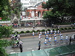
Nathan Road, 2008 Olympic Torch Relay, St Andrew's Church section

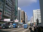
Nathan Road, Mongkok section .
Nathan Road, Prince Edward section

Nathan Road, panorama at night, section Jordan


See also
Web links
- Nathan Road HK (English)
Individual evidence
- ↑ Baedeker travel guide Heiner Gstaltmayr: Hong Kong, Macao . 13th edition. Baedeker travel guide , 2011, ISBN 978-3-8297-1239-2 , pp. 193 ( limited preview in Google Book search).
- ↑ "Nathan Road - with colonial buildings around 1930". In: gwulo.com. Retrieved July 28, 2019 (Chinese, black and white photo - Nathan Road and Dairy Farm Ice & Cold Storage Kowloon (building) - now Kowloon Park).
- ^ "Nathan Road - with colonial buildings around 1958". In: gwulo.com. Retrieved July 28, 2019 (Chinese, color photo - Nathan Road and Whitfield Barracks (left) - now Kowloon Park).
- ↑ Hong Kong Heritage Discovery Center - Former Whitfield Barracks After Adaptive Re-use "(香港 文物 探知 館 - 活化 後 的 前 威菲 路 軍營)" - Chinese, English: [1] - Retrieved December 16, 2015 - amo. gov.hk - Online
- ↑ Hong Kong Heritage Discovery Center - Former Whitfield Barracks After Adaptive Re-use Docent Service "(香港 文物 探知 館 - 活化 後 的 前 威菲 路 軍營 導 賞 服務)" - Chinese, English: [2] - Retrieved on 16. December 2015 - amo.gov.hk - Online
- ↑ "蘋果 日報 - 紙製 模型 重現 威菲 路 軍營" - Apple Daily - reappearance of the Whitfield Barracks as a paper model. In: hk.lifestyle.appledaily.com. June 28, 2013, Retrieved July 28, 2019 (Chinese).
- ^ "1950s Whitfield Barracks". In: gwulo.com. Retrieved July 28, 2019 (English, color photo - Nathan Road and Whitfield Barracks - now Kowloon Park).
- ↑ ". 1960年代初期威菲路軍營" "in early 1960 - Whitfield Barracks". In: oldhkphoto.com. Retrieved July 28, 2019 (Chinese, color photo - now Kowloon Park).
- ^ "1961 Whitfield Barrack View". In: gwulo.com. Retrieved July 28, 2019 (English, color photo - today Kowloon Park).