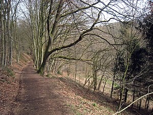
Kupfersiefer Bachtal nature reserve
|
Kupfersiefer Bachtal nature reserve
|
||
|
Kupfersiefer Bachtal nature reserve |
||
| location | Rösrath , North Rhine-Westphalia , Germany | |
| surface | 65.92 ha | |
| Identifier | GL-070 | |
| WDPA ID | 555514042 | |
| Geographical location | 50 ° 54 ' N , 7 ° 12' E | |
|
|
||
| Setup date | 2008 | |
| Framework plan | Landscape plan south district (Bergisch Gladbach, Overath, Rösrath) | |
| administration | Lower landscape authority Rheinisch-Bergischer Kreis | |
The nature reserve Kupfersiefer Bachtal extends between Menzlingen and Schlehecken in the town of Rösrath in the Rheinisch-Bergisches Kreis .
description
The nature reserve encompasses the four-kilometer-long valley of the Kupfersiefer Bach creek from its source near Schlehecken to the confluence with the Sülz near Menzlingen, including a larger and a few small sub-depths . Acid mixed beech forests with partially old wood and a well-developed shrub layer grow on the accompanying hillside forests . The slopes on the upper reaches are often overgrown with lean grassland. In the Bachaue one encounters extensively used or fallow wet and moist grassland.
The area surrounding the nature reserve is intensively cultivated with arable farming. The area therefore represents a valuable deciduous forest relic that is little disturbed by traffic and settlement. The structured mixed beech forest and the near-natural stream are a retreat for typical forms of life in the primeval landscape of the natural area.
Protective purposes
The protection designation was made for the maintenance and development of a largely undisturbed, near-natural stream valley with structurally rich hillside forests and grassland areas. In detail, the following protective purposes were set:
- Preservation and securing of the following protected biotopes : rivers, alluvial forests, wet and humid grassland and still waters,
- Securing the function as a biotope network area of outstanding importance,
- Preservation and development of the near-natural, long stream valley as a multifaceted biotope complex of structurally rich hillside forests, alluvial forests and hillside grassland,
- Preservation and development of the near-natural, largely undisturbed and continuous stream and its source depths,
- Conservation and development of structurally rich hillside and riparian forests,
- Preservation and development of the poor grassland on the slopes and the wet and humid grassland in the floodplain.
See also
Individual evidence
- ↑ a b c Landscape plan of the southern district of Bergisch Gladbach, Overath, Rösrath, pp. 125 - 126 Accessed on November 24, 2017


