Newcastle and Carlisle Railway
| Newcastle – Carlisle | |||||||||||||||||||||||||||||||||||||||||||||||||||||||||||||||||||||||||||||||||||||||||||||||||||||||||||||||||||||||||||||||||||||||||||||||||||||||||||||||||||||||||||||||||||||
|---|---|---|---|---|---|---|---|---|---|---|---|---|---|---|---|---|---|---|---|---|---|---|---|---|---|---|---|---|---|---|---|---|---|---|---|---|---|---|---|---|---|---|---|---|---|---|---|---|---|---|---|---|---|---|---|---|---|---|---|---|---|---|---|---|---|---|---|---|---|---|---|---|---|---|---|---|---|---|---|---|---|---|---|---|---|---|---|---|---|---|---|---|---|---|---|---|---|---|---|---|---|---|---|---|---|---|---|---|---|---|---|---|---|---|---|---|---|---|---|---|---|---|---|---|---|---|---|---|---|---|---|---|---|---|---|---|---|---|---|---|---|---|---|---|---|---|---|---|---|---|---|---|---|---|---|---|---|---|---|---|---|---|---|---|---|---|---|---|---|---|---|---|---|---|---|---|---|---|---|---|---|
|
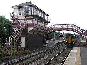
Pedestrian bridge and signal box from 1901 at Haltwhistle stop
| |||||||||||||||||||||||||||||||||||||||||||||||||||||||||||||||||||||||||||||||||||||||||||||||||||||||||||||||||||||||||||||||||||||||||||||||||||||||||||||||||||||||||||||||||||||
| Route length: | 97 km | ||||||||||||||||||||||||||||||||||||||||||||||||||||||||||||||||||||||||||||||||||||||||||||||||||||||||||||||||||||||||||||||||||||||||||||||||||||||||||||||||||||||||||||||||||||
| Gauge : | 1435 mm ( standard gauge ) | ||||||||||||||||||||||||||||||||||||||||||||||||||||||||||||||||||||||||||||||||||||||||||||||||||||||||||||||||||||||||||||||||||||||||||||||||||||||||||||||||||||||||||||||||||||
|
|||||||||||||||||||||||||||||||||||||||||||||||||||||||||||||||||||||||||||||||||||||||||||||||||||||||||||||||||||||||||||||||||||||||||||||||||||||||||||||||||||||||||||||||||||||
The Newcastle and Carlisle Railway , also known as the Tyne Valley Line , is a double-track, standard-gauge, non- electrified railway line that connects Newcastle upon Tyne with Carlisle in Cumbria .
location
The route follows the valley of the Tyne .
history
The line was built by the Newcastle and Carlisle Railway Company (N&CR) on the basis of a permit dated May 22, 1829 in sections from 1834. Chief engineer was 1828-1836 Francis Giles . The main economic drivers for railway construction were the hard coal , lead and iron ore deposits along the Tyne valley. At the same time, it was the first rail link between the east and west coast of the British Isles, which should secure the transport of goods between the industrial center of Newcastle and Ireland . The total distance was opened on June 18, 1838 for passenger and ended in Carlisle first in the station London Road . The Tyne was crossed with a temporary bridge - opened on October 21, 1839 - in Scotswood, west of Newcastle, so that the trains could approach Newcastle city center. Previously, this part of the journey had to be carried out with a passenger ferry.
The N&CR was taken over by the North Eastern Railway (NER) in 1862 . The trains ran to Carlisle Citadel station and the London Road station there was closed. In 1870, the last of the four successive bridges built in Scotswood was built. In 1923, as a first step towards the consolidation of the railway system in Great Britain after the First World War , the Railways Act 1921 merged the NER into the London and North Eastern Railway (LNER) on January 1, 1923 . In 1948 it was nationalized and taken over by British Rail .
In 1982 British Rail closed the historic bridge in Scotswood to save maintenance. The route branched off south of Newcastle in Gateshead from the East Coast Main Line and used its bridge, the King Edward VII Bridge, to cross the Tyne.
Monument protection
Five station buildings and two bridges along the route are classified as cultural monuments.
The railway line runs parallel to Hadrian's Wall . Combined day tickets, which are also valid for the bus line AD122 , which goes to the sights of Hadrian's Wall from April to September, are available. You can change trains in Hexham and Haltwhistle .
Branches
The Newcastle and Carlisle Railway had four branches:
- The Border Counties Railway in Hexham, which joined the Scottish rail network at Riccarton Junction . The line lost passenger traffic in 1956 and was largely closed in 1958.
- The route to Allendale also branched off here and was mainly used to transport minerals. Passenger traffic was stopped in the 1930s and the line was closed in 1953.
- The Alston Line ran from Haltwhistle to Alston , which was initially built because of the lead mines there, but also served passenger transport. The monumental Lambley Viaduct was on the route . It was the last of the branch lines to be shut down in 1976. Part of the route, starting from Alston, is now used by a narrow-gauge museum railway , the South Tynedale Railway , and another part of the route follows the South Tyne Trail hiking trail.
- Another branch led from Brampton station to the town of the same name. This line was closed in 1923. The junction block , Brampton Junction , continued to connect to the Lord Carlisle's Railway , an industrial line older than the Newcastle and Carlisle Railway itself. The Lord Carlisle's Railway had a connection to the Alston branch at Lambley .
traffic
Passenger transport on the route is offered by Northern Rail and First ScotRail with diesel multiple units. The route is heavily used in freight traffic, mainly by DB Cargo UK , formerly: English, Welsh and Scottish Railway (EWS). It is also the shortest connection between the East Coast Main Line and the West Coast Main Line and is therefore an important alternative route in the event of closures or operational disruptions.
Worth knowing
At Brampton station (then: Milton ), Thomas Edmondson was station director in 1836 and invented the Edmondson ticket system there .
photos
Station sign with reference to Hadrian's Wall
literature
- Mike Bridge (Ed.): Track Atlas of Mainland Britain . Bradford on Avon 2009.
- RVJ Butt: The Directory of Railway Stations . Sparkford 1995. ISBN 1-85260-508-1 .
- SC Jenkins: The Alston Branch . 1991.
- JS McLean: The Newcastle and Carlisle Railway . 1948.
- Tony Storey: Haltwhistle Station. Landscape history and industrial archeology in West Northumberland: 1820-2000 . Hayfield School Publication 1998.
- G. Whittle: The Newcastle & Carlisle Railway . Newton Abbot 1979. ISBN 0-7153-7855-4 .
- Alan Young: Railways in Northumberland . Pudsey 2003. ISBN 1-871944-26-0 .


