Niedorp
 flag |
 coat of arms |
| province |
|
| local community |
|
|
Area - land - water |
63.03 km 2 61.59 km 2 1.44 km 2 |
| Residents | 12,272 (December 31, 2011) |
| Coordinates | 52 ° 45 ′ N , 4 ° 52 ′ E |
| Important traffic route |
|
| prefix | 0224, 0226 |
| Postcodes | 1704, 1718-1719, 1731-1736, 1738, 1741, 1746-1747, 1757, 1766-1769, 1775, 1851, 2265 |
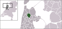
Niedorp ( ) ( West Frisian Nierup ) is a former municipality in the Dutch province of North Holland , Region Westfriesland .
The community of Niedorp merged on January 1, 2012, together with the communities of Anna Paulowna, Wieringen and Wieringermeer, to form Hollands Kroon .
Districts
- Barsingerhorn, near Schagen
- Haringhuizen
- Kolhorn
- Kreil (partially)
- Lutjewinkel
- Moerbeek
- Nieuwe Niedorp (seat of the municipal administration)
- Oude Niedorp
- Terdiek
- Verlaat (partially)
- angle
- Zijdewind.
Location and economy
The municipality is located west of Wieringermeer , north of Heerhugowaard and east of Schagen , where the nearest train station is.
Several small canals run through the municipality, in the past mainly used by inland shipping, today used by water sports tourism. The main source of income for the municipality is still agriculture.
history
The place names of Oude and Nieuwe Niedorp already appeared in a document in 1298. In 1415 the places received a limited town charter (Stede Niedorp) . In 1904 a monastery was built there . a. was used by the Poor Clares ; the building now serves as an educational institution for foreign priestly students.
Barsingerhorn, which was first mentioned in 890 and gradually developed from a series of terps with farms into an elongated dike village, and Haringhuizen were part of the Schagen glory in the Middle Ages .
Kolhorn, a former fishing village that was located on the Zuider Sea coast before the Wieringermeer was drained , was a transshipment port for VOC ships in the 17th century . Between about 1890 and 1930, catching large quantities of anchovies or anchovies brought some prosperity to the village. Later the fishing port was converted into a marina.
Attractions
- The community promotes cycling tours in the area and provides visitors with leaflets with information.
- There are a few small museums, including one on perfume bottles in Winkel and one on motorcycles in Nieuwe Niedorp.
- Barsingerhorn has a remarkable former town hall from the 17th century.
Personalities
- Dirck Rembrantsz van Nierop (1610–1682), astronomer and navigation teacher
- Jessy Kramer (* 1990), national handball player
politics
Distribution of seats in the municipal council
| Political party | Seats | |||
|---|---|---|---|---|
| 1998 | 2002 | 2006 | 2010 | |
| Lokaal Alternatief Democratie Anders | - | - | - | 6th |
| VVD | 3 | 5 | 4th | 3 |
| PvdA | 5 | 4th | 5 | 3 |
| CDA | 3 | 3 | 3 | 2 |
| General concern | 3 | 3 | 3 | 1 |
| GroenLinks | - | - | - | 0 |
| D66 | 1 | - | - | - |
| total | 15th | 15th | 15th | 15th |
Web links
Individual evidence
- ↑ Bevolkingsontwikkeling; regio per maand Centraal Bureau voor de Statistiek , accessed on May 13, 2018 (Dutch)
- ↑ Allocation of seats in the municipal council: 1998 2002 2006 2010 , accessed on May 13, 2018 (Dutch)
