Noguera Ribagorzana
| Noguera Ribagorzana | ||
|
The river in the basin of the |
||
| Data | ||
| location | Spain | |
| River system | Ebro | |
| Drain over | Segre → Ebro → Mediterranean | |
| source | Llacs de Mulleres 42 ° 37 '36 " N , 0 ° 42' 21" O |
|
| Source height | 2450 msnm | |
| muzzle | At Corbins in the Segre coordinates: 41 ° 40 ′ 29 " N , 0 ° 42 ′ 22" E 41 ° 40 ′ 29 " N , 0 ° 42 ′ 22" E |
|
| Mouth height | 165 m | |
| Height difference | 2285 m | |
| Bottom slope | 17 ‰ | |
| length | 133 km | |
| Reservoirs flowed through | Pantà d'Escales, Pantà de Canelles , Pantà de Santa Anna | |
| Medium-sized cities | El Pont de Suert , Alfarràs , Almenar | |
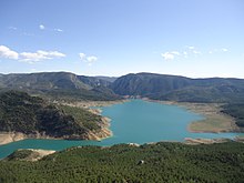
The Noguera Ribagorzana ( Spanish ) or Noguera Ribagorçana ( Catalan ) is a 133-kilometer tributary of the Segre , the upper and middle reaches of which largely form the border between Aragon and Catalonia in Spain . It rises in the Llacs de Mulleres in the Pico de Aneto massif ( Pyrenees ) at an altitude of around 2450 m . Its upper reaches in the Pyrenees to the reservoir of the Pantà d'Escales are accompanied by one of the main connections between Spain and France, the N 230. In the middle reaches, where it is dammed in the Pantà de Santa Anna and Pantà de Canelles, the valley narrows and the road leaves it. South of Montañana, through the Mont Rebei gorge, it divides the Serra del Montsec into the Montsec de l'Estall in the west and the Montsec d'Ares in the east. At Corbins the Noguera flows into the Segre, a few kilometers above Lleida .


