Nordingrå
| Nordingrå | ||||
|
||||
| State : | Sweden | |||
| Province (län): | Västernorrlands Lan | |||
| Historical Province (landskap): | Ångermanland | |||
| Municipality : | Kramfors | |||
| Coordinates : | 62 ° 56 ' N , 18 ° 17' E | |||
| SCB code : | 7604 | |||
| Status: | Crime scene | |||
| Residents : | 282 (December 31, 2015) | |||
| Area : | 0.64 km² | |||
| Population density : | 441 inhabitants / km² | |||
| List of perpetrators in Västernorrland County | ||||
Nordingrå (formerly Nordingråvallen ) is a locality ( tätort ) in the northern Swedish province Västernorrland County and the historic province of Ångermanland . The village at the end of Vågsfjärden , an extension of the Bottenwiek , is part of the municipality of Kramfors .
The place is known for the diverse nature in the area and its idyllic location. Nordingrå can be seen as a synonym for the Höga Kusten , which became a UNESCO World Heritage Site in 2000 . Nordingrå has also always been the cultural center and, seen from this, the heart of this unique coastal landscape.
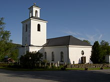
The center of the parish is the "New Church" built between 1820 and 1825. Its forerunner is the "Old Church" (Gamla kyrkan) from the 13th century in the adjacent area , which has only been preserved in foundations .
The best-known person from Nordingrå is the ice hockey player Tobias Enström (* 1984).

