
Bollstabruk
| Bollstabruk | ||||||
|
||||||
| State : | Sweden | |||||
| Province (län): | Västernorrlands Lan | |||||
| Historical Province (landskap): | Ångermanland | |||||
| Municipality : | Kramfors | |||||
| Coordinates : | 63 ° 0 ′ N , 17 ° 40 ′ E | |||||
| SCB code : | 7432 | |||||
| Status: | Crime scene | |||||
| Residents : | 1883 (December 31, 2015) | |||||
| Area : | 5.14 km² | |||||
| Population density : | 366 inhabitants / km² | |||||
| List of perpetrators in Västernorrland County | ||||||

Bollstabruk (unofficially Bollsta ) is a place ( tätort ) in the Swedish province Västernorrland County , in the historical province (landskap) Ångermanland .
location
Bollstabruk belongs to the municipality of Kramfors and within this, since January 1st, 2016, to the district of Ytterlännäs, named after the original church village located a little northeast , and in the southern part of the village (Väja) to the district of Gudmundrå, after the church of this name located on the southern edge of Kramfors . With almost 1900 inhabitants, the place is the second largest town in the municipality. It is a good 40 km as the crow flies north-northwest of the provincial capital Härnösand and about 10 km northwest of Kramfors. The place is located at the northwest end of the Bollstafjärden, an approximately 5 km long bulge in the estuary of the Ångermanälven in the Bay of Bothnia . The eponymous river Bollstaån flows into the bay.
The Reichsstraße 90 runs through Bollstabruk, which follows the Ångermanälven from the European route 4 ( Europaväg 4 ) at Utansjö near the mouth up to Meselefors in Lapland on the European route 45 ( Europaväg 45 ).
In the place there were the train stations Bollstabruk and Dynäs (near the district Väja) on the Ådalsbahn (Ådalsbanan), which connects Sundsvall with Långsele . Since the extensive reconstruction of the line up to 2012, including a new route north of Bollstabruk through the 2411 m long Snarabergstunnel and the closure of the old route along the north side of Bollstafjärden, passenger traffic at both stations has been abandoned. Therefore, the closest passenger stations are now Kramfors and the 7 km northeast of Västeraspby, where the new Botniabahn (Botniabanan) to Umeå , which opened in 2010, begins.
Not far from Västeraspby is the regional airport Höga Kusten Airport (previously also Kramfors- Sollefteå Airport ).
history
Bollstabruk goes back to an ironworks that was built at the mouth of the Bollstaån in the 1730s. There were already plans for this at the end of the 17th century; However, these were not initially implemented. From the middle of the 19th century, timber industry facilities, such as a sawmill , were built around the ironworks . The ironworks was later closed - the last blast furnace was taken out of service in 1899, but the sawmill still exists today as part of Svenska Cellulosa AB .
Since 1965, Väja, about three kilometers south-east of the town center in the direction of Kramfors, has been part of the crime scene. Väja was built as a factory settlement around a 1914-1919 based on a sawmill that had existed there since 1884 at the Dynäs train station. As the towns grew together, the population of Bollstabruk more than doubled in 1965, at that time it was 3399. The paper mill, which has been controlled by the Mondi Group since 2000 , is still one of the largest employers in the Kramfors community.
Administratively, Bollstabruk initially belonged to the parish of Ytterlännäs socken and the later district of Väja to Gudmundrå socken. The rural communities of the same name (landskommun) emerged from these in 1862 . Gudmundrå was already part of the municipality of Kramfors in 1947, which in 1971 became part of the newly formed present municipality (kommun) , while Ytterlännäs was converted into an independent municipality in 1971 and only became part of Kramfors on January 1, 1974.

Kejsarstaden workers' settlement

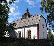
The (new) Ytterlännäs Church near Bollstabruk
The old Ytterlännäs Church
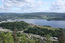
North-western end of Bollstafjärden, on the left the port of Bollstabruk and the Ytterlännäs church

Bollstabruk sawmill 1898

Dynäs paper mill in 1925


Attractions
In Bollstabruk there is a settlement of workers' houses built between 1887 and 1894, called Kejsarstaden. The area is declared as a protected cultural asset with the status of Reich Interest. The former ironworks mansion, which was built in 1738 but has been rebuilt many times, and parts of the factory have also been preserved.
A little north of Bollstabruk is the (new) Ytterlännäs Church, which was built between 1848 and 1854 closer to the then already important factory settlement. The old church (Ytterlännäs gamla kyrka), the oldest parts of which date from the 13th century, is located a good kilometer further east in the direction of Nyland , and has been completely preserved, which is rather untypical for churches in northern Sweden that were primarily replaced by new buildings in the 19th century is.
Sports
The local sports club is called Bollsta IK. Whose women's football team played in the season 1978/79 in the top Swedish division (predecessor of Damallsvenskan ); Ulla-Karin Rönnlund , for example, began her career in the team .
Sons and daughters of the place
- Sven-Erik Westerberg (1925–1959), football player
Web links
Individual evidence
- ↑ a b Statistiska centralbyrån : Land area per Tatort, folkmängd and invånare per square kilometer. Vart femte år 1960 - 2015 (database query)
Perpetrator: Bollstabruk | Docksta | Herrskog | Klockestrand | Kramfors | Lunde | Lungvik | Mjallom | Nordingrå | Nyland | Sandslån | Ullånger
Småorter: mountain | Häggvik and Sund | Hornön | Köja och Nyhamn | Kyrkdal | Lo och Fröksmon | Omne | Priestmon | Skärted, Sprängsviken och Nänsjö | Stream