
Långsele
| Långsele | ||||||
|
||||||
| State : | Sweden | |||||
| Province (län): | Västernorrlands Lan | |||||
| Historical Province (landskap): | Ångermanland | |||||
| Municipality : | Sollefteå | |||||
| Coordinates : | 63 ° 11 ′ N , 17 ° 4 ′ E | |||||
| SCB code : | 7572 | |||||
| Status: | Crime scene | |||||
| Residents : | 1642 (December 31, 2015) | |||||
| Area : | 2.47 km² | |||||
| Population density : | 665 inhabitants / km² | |||||
| List of perpetrators in Västernorrland County | ||||||

Långsele is a locality ( tätort ) in the Swedish province County Västernorrland and the historic province of Ångermanland in the municipality of Sollefteå .
Location and traffic
The place Långsele is located about 10 kilometers west of the main town of Sollefteå on a tributary of the Ångermanälven , the Faxälven . The owns a station on the Stambanan genom övre Norrland called railway line. The Riksväg 87 leads past the place.
Personalities
- Thomas Gradin (* 1956), ice hockey player
- Peter Gradin (* 1958), ice hockey player
- Mona Wessman (* 1948), actress and singer
gallery

Municipal coat of arms
(until 1970)
railway station
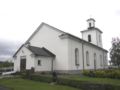
church


Web links
Individual evidence
- ↑ a b Statistiska centralbyrån : Land area per Tatort, folkmängd and invånare per square kilometer. Vart femte år 1960 - 2015 (database query)
Perpetrator: Junsele | Långsele | Näsåker | Ramsele | Sollefteå | Sollefteå norra
Småorter: Arlum och Stöndar | Åsmon | Bäckaskog | Björkå | Ed | Edsele | Forsmo | Helgum | Ödsgårdsmon | Ön norra och Sand södra | Österforse | Råsmon | Resele och Myre | Tjäll | Undrome | Västerrå and Österrå | Viksmon och Märraviken