Nordperd
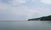
The Nordperd (Perd = Slavic projection) is a cape on Rügen . It is part of the Southeast Rügen Biosphere Reserve and the Mönchgut nature reserve .
The cape forms the easternmost point of the island of Rügen and the district of Vorpommern-Rügen . The headland, which is about 1500 meters long, is in the shape of an isosceles triangle, which tapers to the east in a wooded cliff about 20 meters high. The Nordperd was fortified by coastal protection measures and thus cut off from active processes on the compensation coast .
The Nordperd sub- area of the Mönchgut nature reserve covers 69 hectares. Characteristic features are dry grassland, the sycamore-ash slope forest on the cliff, as well as beaches and shallow water areas.
The northern beach section with the spa promenade of the Baltic resort of Göhren is separated from the south-facing beach of Göhren by Cape Nordperd.
Between the Göhrener Seebrücke and the Nordperd lies the buskam, the largest boulder found in northern Germany to date , which protrudes about a meter from the sea.
The counterpart to the Nordperd is the Südperd , the southeastern tip of Rügen in the municipality of Thiessow . Flat sandy beaches of the Mönchgut peninsula extend between the Nordperd and Südperd, eleven kilometers away , interrupted by the 15-meter-high cliff of the Lobber village .
Web links
Footnotes
- ↑ Archived copy ( Memento from May 21, 2012 in the Internet Archive )
- ↑ Biotope arch dry lawn NSG Bakenberg, Göhren (PDF; 24 kB)
- ↑ Biotope arch cliff in the NSG "Nordperd" (PDF; 25 kB)
- ↑ Biotope arch active cliff north of NSG "Nordperd" (PDF; 26 kB)
Coordinates: 54 ° 20 ′ 26.6 ″ N , 13 ° 45 ′ 53.5 ″ E

