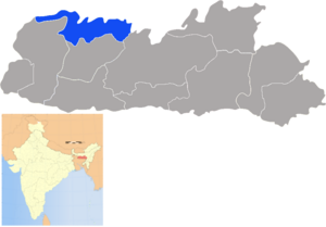
North Garo Hills
| North Garo Hills District | |
|---|---|

|
|
| State | Meghalaya |
| Administrative headquarters : | Resubelpara |
| Area : | 1113 km² |
| Residents : | 172,119 (2011) |
| Population density : | 155 inhabitants / km² |
| Website : | official website |
The North Garo Hills District is a district in the Indian state of Meghalaya . The administrative seat is the city of Resubelpara .
geography
The North Garo Hills district is located in the northwest of Meghalaya on the border with Assam . The area of the district is 1113 square kilometers. Neighboring districts are East Garo Hills to the east and south and West Garo Hills to the west. In the north, the district borders on the Indian state of Assam.
history
The district was created on July 27, 2012 when the then East Garo Hills district was divided. The CD blocks Kharkutta (all municipalities; 51,477 inhabitants) and Resubelpara (all municipalities; 104,514 inhabitants) and 66 municipalities of the CD block Songsak (with 16,128 of the 53,107 inhabitants of the CD block) separated from the former East Garo Hills district and formed the new one North Garo Hills District.
population
According to the 2011 census, the North Garo Hills district has 172,119 residents. With 155 inhabitants per square kilometer, the district is densely populated. Of the 172,119 residents, 152,524 people (88.62 percent) lived in rural communities and 19,595 people in urban areas.
The district of North Garo Hills district is mostly populated by members of the "tribal population" ( scheduled tribes ). They included (2011) 166,701 people (96.85 percent of the district's population). The Dalit ( scheduled castes ) numbered only 99 people in 2011 (0.06 percent of the district's population).
Significant places
In the district of North Garo Hills there is only one urban settlement with the town of Resubelpara.
District population by gender
Of the 172,119 residents, 86,871 (50.47 percent) were male and 85,248 female. This equilibrium is atypical for India, where there is usually a marked increase in men.
District population by language
About 158,000 residents of the district are Garo. Around 7000 people speak Assamese. The Rabha people, who belong to Hinduism, number 4700 people in the district. There are also smaller linguistic minorities speaking Bengali, Hindi and Nepali. These language groups, which together number around 1300 people, are also predominantly Hindus.
Population of the district by confession
In the past 100 years, the majority of the local population has converted to Christianity. Today around 88 percent of the population are Christians. There are also around 7.5 percent Hindus and around 4,000 followers of traditional religions.
education
The goal of full literacy is still a long way off. Of the 142,338 people aged seven and over, 110,097 (77.34 percent) can read and write. For Indian standards, the clear difference between the sexes and the urban / rural ditch is normal. Almost 93 percent of men in the only city (Resubelpara) can read and write. But only just under 72 percent of women in rural communities. The following table provides an overview of the relationships:
| Literacy in the North Garo Hills District | ||||||
| unit | 2011 census | |||||
| number | proportion of | |||||
| TOTAL | 110.097 | 77.34% | ||||
| Men | 57,605 | 80.24% | ||||
| Women | 52,492 | 74.41% | ||||
| TOTAL CITY | 15,566 | 91.66% | ||||
| City men | 7840 | 92.94% | ||||
| City women | 7726 | 90.39% | ||||
| TOTAL COUNTRY | 94,531 | 75.41% | ||||
| Country men | 49,765 | 78.55% | ||||
| Country women | 44,766 | 72.20% | ||||
| Source: 2011 census result | ||||||
administration
With Bajengdoba, Kharkutta and Resubelpara, the district has three Community Development Blocks (CD Blocks; subdistricts).
Individual evidence
Web links
Coordinates: 25 ° 32 ′ 24 ″ N , 90 ° 21 ′ 36 ″ E
