Nukuteatea
| Nukuteatea | ||
|---|---|---|
| Nukuteatea satellite photo | ||
| Waters | Pacific Ocean | |
| Archipelago | Wallis Islands | |
| Geographical location | 13 ° 12 ′ S , 176 ° 11 ′ W | |
|
|
||
| length | 0.7 km | |
| width | 0.18 km | |
| surface | 0.1 km² | |
| Residents | uninhabited | |
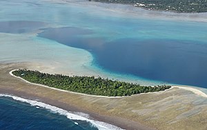
| Aerial view of Nukuteatea | ||
Nukuteatea is an island of the Wallis Islands and politically belongs to the Hihifo district in the Kingdom of Uvea , which forms part of the French overseas territory of Wallis and Futuna .
geography
Nukuteatea lies on the outer ring of the atoll of the Wallis Islands. The nearest islands are Nukuloa in the north and Nukutapu in the south . The main island and largest island in the archipelago, Uvea , is 1.5 miles to the southwest. The island itself is slightly curved and stretched from northwest to southeast. At the northwest end there is a narrow sandbar that extends about 180 meters long just above the sea surface .
Nukuteatea is overgrown with trees and relatively flat. There is a small elevation in the northwestern part. There is a sandy beach around the island .
use
The island is actually uninhabited, but there are several houses and huts on it that are not permanently inhabited. There is also a chapel in the south-east called Chapelle de Nukuteatea , which can also be seen from the air thanks to its blue roof (see the aerial photo on the right).
Individual evidence
- ↑ Île Nukuteatea (Iceland). Retrieved May 13, 2017 (English).
- ↑ Google Maps. Retrieved May 13, 2017 .


