
Upper fire
|
Upper fire
Market Neuhaus an der Pegnitz
Coordinates: 49 ° 40 ′ 0 ″ N , 11 ° 34 ′ 0 ″ E
|
|
|---|---|
| Height : | 374 m above sea level NN |
| Residents : | 0 (1987) |
 Memorial stone
|
|
Oberbrand was once a district of the Neuhaus an der Pegnitz market in the district of Nürnberger Land in Middle Franconia .
description
The hamlet was part of the Neuhaus an der Pegnitz market and until May 1, 1978 belonged to the municipality of Höfen .
In order to supply the city of Nuremberg with drinking water, its inhabitants had to leave the ancient cultivated land . For a long time the water from the nearby Haselhof springs was no longer sufficient and new springs had to be tapped. The localities Fischstein , Oberbrand, Unterbrand and Rauhenstein had to be dissolved. Between 1960 and 1975 all properties were demolished and the residents were relocated. The place was on the western edge of the Pegnitz Valley north of Ranna and west of the Nuremberg – Cheb railway line . In the north of Oberbrand lies the Hasensee, in the south there were Unterbrand and Rauhenstein with the Kalvarienberg. Fischstein was once located to the north. The natural monument Eulenloch , the Upper and Lower Kammerweiher and the Kammerberg (436 m) are located in the vicinity .
Upper and lower fire were separated by the Nuremberg – Cheb railway line . The road bridge over the railroad tracks was replaced by a pedestrian bridge in the 2000s.
Picture gallery
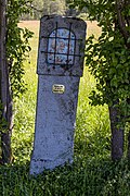
A wayside shrine at Oberbrand

The Hasensee

Railway line Nuremberg – Cheb, view to the south


literature
- Nuremberg country . Karl Pfeiffer's Buchdruckerei und Verlag, Hersbruck 1993. ISBN 3-9800386-5-3
- Andreas Dimler: Neuhaus market town - yesterday and today . Animus Kunstverlag, 1998, ISBN 3-9806507-1-5 .
Individual evidence
- ↑ [1]
- ↑ BayernAtlas, Zeitreise, Oberbrand around 1960 (accessed on June 3, 2019)
Web links

Bärnhof | Dark Mill | Hammer scrap | Courtyards | Krottensee | Mosenberg | Neuhaus an der Pegnitz | Rehberg | Rothenbruck | Brick hut
Former districts: Fischstein | Overfire | Rinnenbrunn | Underfiring