Oberhasli ZH
| Oberhasli | ||
|---|---|---|
| State : |
|
|
| Canton : |
|
|
| District : | Dielsdorf | |
| Political community : | Niederhasli | |
| Postal code : | 8156 | |
| Coordinates : | 679 896 / 257 722 | |
| Height : | 430 m above sea level M. | |
| map | ||
|
|
||
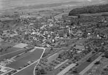
Oberhasli is a village in the Niederhasli municipality in the Dielsdorf district of the canton of Zurich . It has its own zip code and was a civil parish until the end of 2009 .
geography
Oberhasli is located in the Glatttal region in the Zurich Unterland at 430 m above sea level. M.
More precisely, Oberhasli is located southeast of Niederhasli and Mettmenhasli , southwest of Oberglatt and northwest of Rümlang . The village center lies on the Haslibach , while the new housing estates extend over the southern slope of the Hasliberg .
history
Earlier names recorded in writing are Obern Hasla , Oberhasla , Oberhaslach , Oberhasle , Obernhaslen and Oberhaslen
The lower jurisdiction , previously with the Counts of Habsburg , was given to the Lords of Rümlang as pledge in 1331 . In 1465 it came to the Zurich citizen Ulrich Schwegler and at the end of the same century to the city of Zurich .
From 1442 to 1798 Oberhasli belonged to the Obervogtei Neuamt of the city-state of Zurich, whose area previously belonged to the County of Kyburg . Between 1798 and 1803 it belonged to the Bülach district of the Helvetic Republic and from 1803 to the canton of Zurich . Here it was initially again part of the Bülach district, after which it belonged to the Regensberg Oberamt , which was converted into the Regensberg district in 1831. In 1871 this was renamed the Dielsdorf district.
In 1467 the village had 14 households, in 1634 there were 201 inhabitants and in 2000 it had 1465 inhabitants.
Blazon
The coat of arms, used for the first time in 1946, shows a blue grape with a stem and two yellow leaves on a red background.
Attractions
Web links
- Martin Illi: Oberhasli ZH. In: Historical Lexicon of Switzerland .


