
Oberglatt ZH
| ZH is the abbreviation for the canton of Zurich in Switzerland and is used to avoid confusion with other entries in the name Oberglatt . |
| Oberglatt | |
|---|---|
 |
|
| State : |
|
| Canton : |
|
| District : | Dielsdorf |
| BFS no. : | 0092 |
| Postal code : | 8154 |
| UN / LOCODE : | CH ORG |
| Coordinates : | 681 511 / 259118 |
| Height : | 431 m above sea level M. |
| Height range : | 412-470 m above sea level M. |
| Area : | 8.25 km² |
| Residents: | 7108 (December 31, 2018) |
| Population density : | 862 inhabitants per km² |
|
Proportion of foreigners : (residents without citizenship ) |
36.7% (December 31, 2018) |
| Mayor : | Roger Rauper ( independent ) |
| Website: | www.oberglatt.ch |
 Oberglatt on the Glatt |
|
| Location of the municipality | |
  |
|
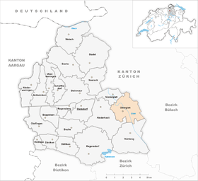
Oberglatt is a municipality in the district of Dielsdorf in the canton of Zurich in Switzerland .
coat of arms
- In silver over a recumbent, formed red crescent three red stars (2,1)
The coat of arms goes back to Johannes Krauer (around 1860); the element half moon is based on the historical coat of arms of the Obervogtei Neuamt , to which Oberglatt belonged since 1442. The official introduction as the municipal coat of arms dates back to 1928.
geography
The municipality of Oberglatt includes the town of the same name on both sides of the Glatt , the district of Hofstetten , a former civil parish , and the Grafschaft area on the right bank of the Glatt . 51.5% of the municipal area is agricultural land, 10.6% is forest, 12.1% is settlement area and 18.6% is used for traffic, 1.8% is water.
The municipality of Oberglatt borders Höri in the north, Bachenbülach in the northeast, Winkel in the east, Rümlang in the south, Niederglatt in the southwest and Niederhasli in the northwest .

politics
The SVP has 47.0%, the SP 19.5%, the FDP 12.7%, the Greens 5.9%, the CVP 4.7%, and the EPP 4.0% of the vote.
Roger Rauper has been the mayor ( independent ) since 2018 (as of September 2019).
history
The earliest documented mention of the place name Oberglatt still in existence dates back to 1153.
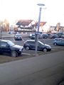
Economy and Infrastructure
traffic
Oberglatt has been accessible by rail since May 1, 1865. The station is the starting point of the Wehntalbahn to Dielsdorf - Niederweningen , which branches off the main line Oerlikon - Bülach of the former Bülach-Regensberg-Bahn (BR). The railway lines have belonged to the Swiss Federal Railways (SBB) since 1902 , and the station has been served by S-Bahn Zurich trains since May 1990 . Until 2015, the half-hourly S 5 Rafz - Bülach - / Niederweningen - Oberglatt - Zurich HB - Uster - Pfäffikon SZ in the Zürcher Unterland ran with two end points, which were served alternately from Oberglatt. The S55 Niederweningen - Oberglatt, which ran from December 10, 2006 to December 13, 2015, made a second connection every hour from Wehntal and Dielsdorf to the S 5 in Oberglatt during the day . Since the opening of the cross-city line on December 13, 2015, the S 15 Rapperswil - Uster - Zurich HB - Oberglatt - Niederweningen has now been running every half hour . The S 9 Schaffhausen - Rafz - Zurich HB - Stettbach - Uster also runs every half hour and thus provides a quarter of an hour between Zurich HB and Oberglatt.
From the station Oberglatt from that of serving post bus powered ZVV -Buslinie 510 (Zurich airport Stadel bei Niederglatt ) on the municipality stops Rietli , center and Mösli Hofstetten . At rush hour, an offshoot of line 510 serves the Bahnhof and Mösli stops on the Oberglatt - Steinmaur line , with line 504 ( Bülach - Bachenbülach - Oberglatt Bahnhof) the district east of the Glatt is opened up. Oberglatt and Bülach can be reached with the Postbus line 525 and also serves Niederglatt .
Attractions
photos

Covered Glattbrücke

Altllauf der Glatt nature reserve
Oberglatt, snapshot from the train
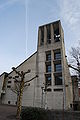
Evangelical Reformed Church Oberglatt
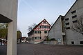
Village center of Oberglatt

Parish hall in Oberglatt


Personalities
- Fredy Lienhard (1927–2012), cabaret artist and actor.
literature
- Hermann Fietz: The art monuments of the canton of Zurich, Volume II: The districts of Bülach, Dielsdorf, Hinwil, Horgen and Meilen. (= Art Monuments of Switzerland. Volume 15). Edited by the Society for Swiss Art History GSK. Bern 1943. DNB 365803049 .
Web links
- Martin Illi: Oberglatt ZH. In: Historical Lexicon of Switzerland .
- Official website of the municipality of Oberglatt
- Statistical data for the municipality of Oberglatt
Individual evidence
- ↑ Permanent and non-permanent resident population by year, canton, district, municipality, population type and gender (permanent resident population). In: bfs. admin.ch . Federal Statistical Office (FSO), August 31, 2019, accessed on December 22, 2019 .
- ↑ Data on the resident population by home, gender and age (community profile). Statistical Office of the Canton of Zurich, accessed on December 22, 2019 .
- ↑ Peter Ziegler, Die Gemeindewappen des Kantons Zürich, Antiquarian Society in Zurich, coat of arms drawings by Walter Käch and Fritz Brunner, Zurich 1977, p. 77 .
Bach's | Boppelsen | Box | Dällikon | Dänikon | Dielsdorf | Hüttikon | Neerach | Niederglatt | Niederhasli | Niederweningen | Oberglatt | Oberweningen | Otelfingen | Regensberg | Regensdorf | Rümlang | Schleinikon | Schöfflisdorf | Stadel near Niederglatt | Steinmaur | Weiach
Former communities: Affoltern near Zurich Raat-Schüpfheim | Windlach
Canton of Zurich | Districts of the Canton of Zurich | Municipalities of the Canton of Zurich