Oberschur (Krombach)
|
Upper shear
community Krombach
Coordinates: 50 ° 5 ′ 10 ″ N , 9 ° 11 ′ 16 ″ E
|
|
|---|---|
| Height : | 320 m above sea level NN |
| Residents : | 165 (June 20, 2012) |
| Postal code : | 63829 |
| Primaries : | 06029 Mömbris, 06024 Krombach |
|
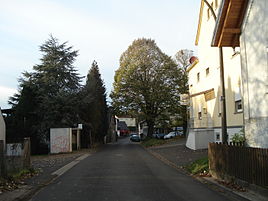
Center of Oberschur
|
|
Oberschur is a district of the municipality of Krombach in the Lower Franconian district of Aschaffenburg .
geography
Oberschur is located in the Kahlgrund on the edge of the Spessart at 320 m above sea level. NN . With 165 inhabitants (as of 2012) it is the only official district of the municipality of Krombach. The place is between Dörnsteinbach and Hauenstein .
Surname
The name Oberschur goes back to the word Schar (see also ploughshare ). The addition of Ober distinguishes it from the village of Unterschur down the valley. The place is popularly called "Öwwerschur".
history
On July 1, 1862, the Alzenau district office was formed, on whose administrative territory Oberschur lay. In 1939, as everywhere in the German Reich, the designation district was introduced. Oberschur was now part of the Alzenau district in Lower Franconia (license plate ALZ ). With the dissolution of the Alzenau district in 1972, Oberschur became part of the newly formed Aschaffenburg district (license plate AB ).
Others
- The phone code of the Mömbris store in Oberschur is sometimes used.
Web links
Individual evidence
- ↑ Google Earth: measured in the center of the town
- ↑ Registration register of the administrative community Schöllkrippen
- ^ Chronicle of the Mömbris market
