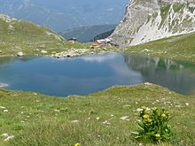
Obstanser See
| Obstanser See | ||
|---|---|---|

|
||
| The Obstanser See to the south | ||
| Geographical location | Carnic Alps , Tyrol | |
| Drain | Winkler Bach | |
| Data | ||
| Coordinates | 46 ° 40 '59 " N , 12 ° 29' 35" E | |
|
|
||
| Altitude above sea level | 2300 m above sea level A. | |
| surface | 3 ha | |
| scope | 750 m | |
| Maximum depth | 8 m | |
The Obstanser See is a 3 hectare mountain lake in the Carnic Alps in East Tyrol .
geography
The lake is located in the municipality of Kartitsch at an altitude of 2300 m above sea level. A. below the Carnic main ridge, which forms the border with the Italian province of Belluno . The lake is framed by the peaks Cima Frugnoni ( 2561 m above sea level ), Pfannspitze ( 2678 m above sea level ) and Roßkopf ( 2603 m above sea level ). The Obstansersee Hut is located on the north bank .
With an area of around 3 hectares, it is the largest lake on the Carnic Main Ridge after Lake Wolayer . The lake floor is almost flat for long stretches with a depth of seven to eight meters, the greatest measured depth is 8.3 m.
The lake receives three small tributaries from the north, west and southwest. It drains via a stream at the north end, which disappears after a short distance in a ponor in the karst , flows through a cave system and, after overcoming around 170 meters of altitude, emerges again in the Obstans gargoyle together with other karst waters. The stream then flows through the Winklertal to the Gailbach .
Emergence
The creation of the Obstanser See is probably due to the glacier that covered the Hinteralm, the slope between today's lake and the main ridge, in the Ice Age . After the glacier melted, the lake formed in its tongue basin and was dammed by a bar running in a west-east direction.
nature
The Obstanser See is a high mountain lake with warm surface, where the warming in summer only penetrates very slowly into the depths. The temperature hardly rises above 10 ° C, and the lake is covered in ice for around 8 months a year. It has a clear winter thermocline ; no thermocline was observed in summer. The water is clear with a depth of over 5 meters. It has a high iron content, but a low oxygen content, as in other high mountain lakes, the strong oxygen consumption in the deep water during the ice cover is likely to be responsible for this.
Flora and fauna
The lake is rich in nannoplankton and there are trout fish that were used in the 19th century.
The bank is partly formed by heaps of rubble, partly it is greened and grazed. In the silting area of the north bank, u. a. Alpine bluegrass , annual bluegrass , alpine timothy grass , turf sedge , Scheuchzer's cottongrass , brown sedge , small-flowered sedge , chamois bulrush , herb willow , bitter foam herb , chickweed willowherb and alpine soldanelle . Between the flowering plants there is a rich algae flora with diatoms , green algae , yoke algae and ornamental algae .
leisure
The Obstanser See is a popular hiking destination that can be reached from Kartitsch through the Winklertal or via the Carnic High Trail . Pedal boats can be rented on the lake.
Web links
Individual evidence
- ↑ a b TIRIS - Tyrolean regional planning and information system
- ↑ a b c d e f Fritz Turnowsky: The Obstanser See in the Carnic main chain. In: Carinthia 11, 64 (1954), pp. 124–132 ( PDF; 823 kB )
- ↑ Eckart Herrmann, Christoph Spötl, Rudolf Pavuza, et al .: The karst area near Lake Obstanser See in East Tyrol . In: Höhlenkundliche Mitteilungen, Volume 47, Volume 61 (2009), pp. 25–60 ( PDF; 3.6 MB ( memento from October 19, 2013 in the Internet Archive ))


