Oleni (Kara Sea)
| Oleni | ||
|---|---|---|
| Waters | Kara Sea | |
| Geographical location | 72 ° 24 ' N , 77 ° 45' E | |
|
|
||
| length | 53 km | |
| width | 27 km | |
| surface | 1 197.4 km² | |
| Highest elevation | 16 m | |
| Residents | uninhabited | |
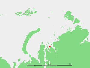
| Location of Oleni | ||
Oleni ( Russian Остров Олений , Ostrov Oleni , German "Reindeer Island") is a 1,197.4 km² Russian island in the southern Kara Sea, part of the Arctic Ocean . Administratively, the uninhabited island belongs to the Tasowski Rajon in the Yamal-Nenets Autonomous Okrug in the north of the north Siberian Tyumen Oblast .
Geographical location
Oleni is located about 2 km northwest of the coast of the Gydan Peninsula , part of the Asian mainland , from which it is separated by the Oleni Strait , and about 30 km southwest of the Sibiryakov Island ( belonging to the Krasnoyarsk region), from which it is eastward by the in the Yenisei Gulf via conductive Owzyna strait is separated, and east of Jawai peninsula , from which it through the northern part of there minimally approximately 38.5 kilometers wide Gydanbucht separated. To the south of the Oleni Island are the Prokljatye Islands and to the north-northwest in the Kara Sea lies the distant Neupokoyeva Island .
The island is a maximum of 53 km long, up to 27 km wide and its coastline is 146.3 km long.
Oleni is part of the Gydan-Sapowednik , established in 1996 , one of the larger nature reserves in Russia.
Landscape, fauna and climate
The coast of Oleni is mostly flat and hardly rugged, but especially in the south-east and south it has small bays. In the north there is a small sand bank in front of it. The island is consistently flat, reaches a maximum height of 13 m and is traversed by small flowing waters that flow into the surrounding straits, bays or directly into the Kara Sea. There are also numerous lakes, most of which are located at the sources of the rivers, and extensive swampy areas.
Since the island lies in the tundra vegetation zone, the vegetation is limited to mosses , lichens and grasses . The winters are long and extremely cold, the summers short and cold. There is permafrost , which thaws more and more in the summers.
Residents and fishing
There are no permanent residents on the island, but in summer, when the sea around the island is less or no longer covered with pack ice , fishermen live in a few simple huts.
See also
Individual evidence
- ↑ a b Oleniy (Oleni Island) on islands.unep.ch (English)
- ↑ Gydan-Sapowednik in the information and information system Specially Protected Natural Areas of Russia of the Center for Nature Conservation (Russian)
-
↑ Topographic map ( Memento of the original from March 4, 2016 in the Internet Archive ) Info: The archive link was inserted automatically and has not yet been checked. Please check the original and archive link according to the instructions and then remove this notice. (1: 200.000, Bl. S-43-XXXV, XXXVI, Ed. 1986), Oleni-West- and Südwestteil u. a. with surrounding roads and Gydan Bay (left), Prokljatye Islands (below) and Gydan Peninsula (right and below) on maps43.narod.ru (with heights above sea level)
see also connection map : Topographic map (1: 200,000, S- 44-XXXI, XXXII, Ed. 1988), Oleniinsel u. a. with the Gydan Peninsula (below), the Mongotschejacha estuary there (Sosnowaya; flowing diagonally), Gydan Bay (below left) and Jenisseigolf (above right) on maps44.narod.ru (with heights above sea level)

