Sibiryakov Island
| Sibiryakov Island | ||
|---|---|---|
| map | ||
| Waters | Kara Sea | |
| Geographical location | 72 ° 54 ′ N , 79 ° 11 ′ E | |
|
|
||
| length | 38 km | |
| width | 27 km | |
| surface | 846.7 km² | |
| Highest elevation | 33 m | |
| Residents | uninhabited | |
| Location in the Kara Sea | ||
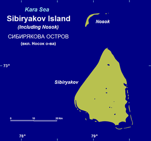
The Siberyakov Island ( Russian Остров Сибирякова ) or Kuskin Island ( Russian Кузькин остров ) is an 846.7 km² Russian island at the transition from the Yenisei gulf to the Arctic Ocean (southern) Kara Sea . Administratively, it belongs to Krasnoyarsk Krai . It was named in 1878 by the Swede Adolf Erik Nordenskiöld after his patron , the Russian gold industrialist Alexander Sibirjakow , and is uninhabited.
Geographical location
Siberyakov Island is located around 30 km north of the coast of the Gydan Peninsula and around 30 km northeast of Oleni Island (both belonging to the Yamal-Nenets Autonomous Okrug ), from which it is separated by the Ovzyn Strait , and around 35 km to the west the Taimyr peninsula , from which it is separated by a strait (also known as the Jenisseigolf ) . To the southeast, the actual Yenisei gulf leads over to the Yenisei which flows into it. North of the island about 16 km away in the Kara Sea is the small island of Nosok , to which the elongated sandbank Severnaya Sibiryakovskaya Otmel leads.
The island is a maximum of 38 km long, up to 27 km wide, and its coastline is 129.7 km long.
The island and the surrounding waters are part of the Bolshoi Arktitscheski Sapovednik (Большой Арктический государственный природный заповедник) , the largest nature reserve in Russia.
Landscape, fauna and climate
The coast of the Siberyakov Island is for the most part flat and hardly rugged, but criss-crossed by small bays. In front of it are small elongated islands and sandbanks to the southeast and west. The topographical shape of the island is hilly, reaches a maximum height of 33 m and is crossed by small rivers that flow into the Jenisseigolf or the Kara Sea. There are also small lakes and swampy areas at the sources of some rivers.
Since the island lies in the tundra vegetation zone, the vegetation is limited to mosses , lichens and grasses . The winters are long and extremely cold, the summers short and cold. There is permafrost , which thaws more and more in the summers. About 10,000 pairs of different sea birds breed on the island . It is designated by BirdLife International as an Important Bird Area (RU002).
Residents and fishing
There are no permanent residents on the island, but in summer, when the sea around the island is less or no longer covered with pack ice , fishermen live in a few simple huts.
See also
Individual evidence
- ↑ a b Sibiryakova ( Sibiryakov Island) on islands.unep.ch (English)
- ↑ a b Topographic map (1: 200.000, Bl. S-44-XXV, XXVI, edition 1956), Sibirjakow-Insel u. a. with the island of Nosok (above) and the sandbank Severnaya Sibirjakowskaja Otmel leading to it on maps44.narod.ru (with heights above sea level)
- ↑ Sibiryakova island on the BirdLife International website, accessed on January 14, 2013.


