Orbiquet
| Orbiquet | ||
|
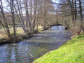
The river at Le Mesnil-Guillaume |
||
| Data | ||
| Water code | FR : I02-0400 | |
| location | France , Normandy region | |
| River system | Touques | |
| Drain over | Touques → English Channel | |
| source | in the municipality of La Folletière-Abenon 48 ° 58 ′ 33 ″ N , 0 ° 25 ′ 36 ″ E |
|
| Source height | approx. 139 m | |
| muzzle | in the city of Lisieux in the Touques coordinates: 49 ° 8 ′ 32 " N , 0 ° 13 ′ 21" E 49 ° 8 ′ 32 " N , 0 ° 13 ′ 21" E |
|
| Mouth height | approx. 43 m | |
| Height difference | approx. 96 m | |
| Bottom slope | approx. 3.2 ‰ | |
| length | 30 km | |
| Discharge at the Beuvillers A Eo gauge : 326 km² |
MQ Mq |
2.8 m³ / s 8.6 l / (s km²) |
| Right tributaries | Courtonne | |
| Small towns | Lisieux | |
The Orbiquet is a river in France that runs in the Calvados department in the Normandy region . It rises in the municipality of La Folletière-Abenon , where the top 800 meters are sometimes underground and the water only then comes to light in a karst spring . The Orbiquet generally drains in a north-westerly direction through the natural landscape of the Pays d'Auge and flows into the Touques after 30 kilometers in the urban area of Lisieux as a right tributary . A second branch of the estuary already reaches the Touques about 300 meters further upstream.
Places on the river
(Order in flow direction)
- La Folletière-Abenon
- Orbec
- Saint-Martin-de-Bienfaite , municipality of Saint-Martin-de-Bienfaite-la-Cressonnière
- La Chapelle-Yvon
- Le Mesnil-Guillaume
- Glos
- Beuvillers
- Lisieux
Web links
Commons : Orbiquet - collection of images, videos and audio files
Individual evidence
- ↑ Source geoportail.gouv.fr
- ↑ estuary geoportail.gouv.fr
- ↑ a b The information on the river length is based on the information about the Orbiquet at SANDRE (French), accessed on November 14, 2013, rounded to full kilometers.
- ↑ hydro.eaufrance.fr (station: I1103010 , option: Synthèse ) .
