Oued Zousfana
| Oued Zousfana | ||
|
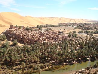
Taghit in the valley of the Oued Zouzfana |
||
| Data | ||
| location | Figuig Province in Morocco and Bechar in Algeria | |
| River system | Oued Saoura | |
| Drain over | Oued Saoura → Sebkha el Melah | |
| Head of the valley | North side of the Moroccan-Algerian border mountains west of Figuig 32 ° 8 ′ 7 ″ N , 1 ° 45 ′ 43 ″ W |
|
| Source height | approx. 1575 m | |
| muzzle | Confluence at Igli with the Oued Guir to the Oued Saoura Coordinates: 30 ° 29 ′ 11 ″ N , 2 ° 18 ′ 18 ″ W 30 ° 29 ′ 11 ″ N , 2 ° 18 ′ 18 ″ W |
|
| Mouth height | approx. 466 m | |
| Height difference | approx. 1109 m | |
| Bottom slope | approx. 3.4 ‰ | |
| length | Valley path 330.5 km | |
The Oued Zousfana is a river in southern Morocco and the Algerian Sahara, the upper reaches of which flows through the Figuig province in the Oriental region . It is the eastern of the two main source rivers of the Oued Saoura in the Algerian Sahara ( Bechar province ).
course
The valley of the Oued Zousfana has its origin on the north side of the mountain range at Jbel Grouz (approx. 1880 m ) in the Moroccan-Algerian border mountains and leaves the mountain valleys to the north and after 9 km it turns at the foot at a right angle to the east. Here it drains the plateau where the N17 national road leads to Figuig . At kilometer 56, the Oued Zousfana makes the next change of direction when it reaches the Moroccan eastern border. It describes a 180-degree turn to the right and thus circles the oasis town of Figuig on three sides, with the bottom of the valley forming the border between Morocco and Algeria for about 24 km. At kilometer 81, its course bends south to break through one of the last mountain ranges of the Atlas Mountains and, with a general south-south-west direction, take the path into the sandy deserts of the Sahara. Its valley forms the western border of the western Great Erg and offers space for an important oasis city , for the Taghit municipality , which it reaches at kilometer 266. Four kilometers north of the commune of Igli , the Oued Zousfana finally reaches the union with the Oued Guir to Oued Saoura after 330.5 km of the valley path .
The Algerian national road 6B accompanies the dry valley on long stretches on the way from the Sahara Atlas to Iglit.
Individual evidence
- ↑ Height of the valley head according to the contour lines on the map at Geonames
- ↑ Muzzle height according to Geonames
- ↑ Measure distance with google maps
Web links
- Oued Zousfana at geoview
-
Topographic map of Morocco with all major rivers in the country shows the course of the river described here
(upper reaches different, map display orographically impossible) - L'oued Zousfana at: Géographie militaire. Livre VI. Algérie et Tunisie, par le Colonel Niox 1890, pages 82 and 83
