Oymaağaç (Vezirköprü)
| Oymaagac | ||||
|
||||
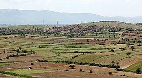
 Oymaağaç from the west |
||||
| Basic data | ||||
|---|---|---|---|---|
| Province (il) : | Samsun | |||
| District ( ilçe ) : | Vezirköprü | |||
| Coordinates : | 41 ° 12 ' N , 35 ° 26' E | |||
| Height : | 300 m | |||
| Residents : | 1,752 (2018) | |||
| Telephone code : | (+90) 362 | |||
| Postal code : | 55900 | |||
| License plate : | 55 | |||
| Structure and administration | ||||
| Muhtar : | Vehbi Yüksel | |||
Oymaağaç is a former village in the Vezirköprü district of the northern Turkish province of Samsun . Today it is part of the district center Vezirköprü. Oymaağaç is about seven kilometers north of Vezirköprü and 75 kilometers west of the provincial capital Samsun . The place is connected by a country road with Vezirköprü and the trunk road D-030 from Kastamonu to Havza . It is located on the northern slope of the Tavşan Dağı mountain range . About five kilometers to the north is the Altınkaya Barajı reservoir , in which the Kızılırmak is dammed.
On the western edge of the village is the settlement hill Oymaağaç Höyük, which probably contains the remains of the Hittite city of Nerik . It has been researched by a team from the Free University of Berlin since 2005 .
Web links
Individual evidence
- ↑ Nufusu.com Oymaağaç , accessed July 10, 2019
- ↑ SAMSUN VEZİRKÖPRÜ OYMAAĞAÇ MAHALLE MUHTARLIGI , July 10, 2019

