Pakaraka
| Pakaraka | ||
| Geographical location | ||
|
|
||
| Coordinates | 35 ° 22 ′ S , 173 ° 57 ′ E | |
| Region ISO | NZ-NTL | |
| Country |
|
|
| region | Northland | |
| District | Far North District | |
| Ward | Bay of Islands - Whangaroa Ward | |
| Residents | few | |
| height | 82 m | |
| Post Code | 0472 | |
| Telephone code | +64 (0) 9 | |
| Photography of the place | ||
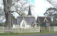
 Holy Trinity Church in Pakaraka |
||
Pakaraka is a settlement in the Far North District of Northland on the North Island of New Zealand .
Origin of name
The name of the settlement is made up of “ pa ”, the Māori language for “village”, and “ karaka ”, the name for a native tree. For the local Māori from the Iwi of the Ngāpuhi , the area is called Tai-a-mai .
geography
The settlement is located around 11 km west-northwest of Kawakawa and around 12 km east of Lake Omapere . The New Zealand State Highway 1 runs through the settlement and the New Zealand State Highway 10 branches off from State Highway 1 to the north in the settlement .
history
At the foot of Mount Pouerua , a 270 m high basalt cinder cone that belongs to the Kaikohe - Bay of Islands Volcanic Field , there was a Pā of the earlier Māori population. The village and the fortifications were explored during excavations in the 1980s.
In 1845 Pakaraka was the site of individual armed conflicts as part of the Flagstaff War . After the Battle of Ohaeawai on June 23, 1845, British troops destroyed Te Haratua's Pā near Pakaraka on July 16, 1845 .
Education
With the Pakaraka School, the settlement has a primary school with grades 1 to 8. In 2014, 59 students attended the school.
Attractions
- Passed to its destination in 1873, Holy Trinity Church was built at the initiative of his wife in honor of Henry Williams , a Church Missionary Society missionary who retired in Pakaraka . It replaced the church built by Henry Williams in 1850-1851 . The building was registered as a monument in 1984 with the number 65 by the New Zealand Historic Places Trust .
- The Retreat is a listed building where missionary Henry Williams lived with his family until his death in 1867. The building is registered under number 70.
Personalities
- Hone Heke (around 1810-1850), chief of the Ngāpuhi , was born in 1807 or 1808 in Pakarake . He was buried in secret in the settlement in August 1850. In 2011, the remains of his body were reburied due to possible construction projects on the site.
- Henry Williams (1792–1867), Church Missionary Society (CMS) missionary
- Edward Marsh Williams , son of Williams
- Henry Williams , politician and son of Williams
Photo gallery
literature
- Helga Neubauer: Pakaraka . In: The New Zealand Book . 1st edition. NZ Visitor Publications , Nelson 2003, ISBN 1-877339-00-8 , pp. 109 f .
Individual evidence
- ^ Neubauer: Pakaraka . In: The New Zealand Book . 2003, p. 109 .
- ↑ Elsdon Best : The Pa Maori . Whitcombe and Tombs , 1927, Old Forts of the Taiamai District, Bay of Islands , S. 245 ff . (English, online [accessed August 26, 2017]).
- ↑ Topo250 maps . Land Information New Zealand , accessed August 26, 2017 .
- ^ Doug G. Sutton, Louise Furey, Yvonne M. Marshall : The archeology of Pouerua . Auckland University Press , 2003, ISBN 1-86940-292-8 (English).
- ^ Robert Burrows : Extracts from a Diary during Heke's War in the North in 1845 . Upton and Company , Auckland 1886, p. 3 ff . (English, online [accessed August 26, 2017]).
- ↑ James Cowan : The New Zealand Wars: a history of the Maori campaigns and the pioneering period . Volume I : 1845-1864. RE Owen , Wellington 1922, pp. 73–144 (English, online [accessed August 26, 2017]).
- ^ Pakaraka School . Education Review Office , accessed August 26, 2017 .
- ^ Holy Trinity Church (Anglican) . Heritage New Zealand , accessed August 26, 2017 .
- ^ The Retreat . Heritage New Zealand , accessed August 26, 2017 .
- ↑ Freda Rankin Kawharu : Heke Pokai, Hone Wiremu . In: Dictionary of New Zealand Biography . Volume 1 , 1990 (English, online [accessed August 26, 2017]).


