Kawakawa
| Kawakawa | ||
| Geographical location | ||
|
|
||
| Coordinates | 35 ° 23 ′ S , 174 ° 4 ′ E | |
| Region ISO | NZ-NTL | |
| Country |
|
|
| region | Northland | |
| District | Far North District | |
| Ward | Bay of Islands - Whangaroa Ward | |
| Residents | 1 218 (2013) | |
| height | 17 m | |
| Post Code | 0210 | |
| Telephone code | +64 (0) 9 | |
| website | www.kawakawa.co.nz | |
| Photography of the place | ||
 Railway line in the middle of the main street of Kawakawa |
||
Kawakawa is a place in the Far North District of the Northland regionon the North Island of New Zealand .
Origin of name
Kawakawa is the name of a shrub that grows in the area.
geography
Kawakawa is located about 45 km north-northwest of Whangarei at the confluence of the Waiōmio Stream and the Waiharakeke Stream in the Kawakawa River , which flows north of the place to the east. Neighboring places are Moerewa , around 5 km to the west and Ōpua , around 9 km to the northeast, at the Waikare Inlett .
history
Originally, Kawakawa was a place where flax was processed at the beginning of the 19th century . When coal was found in the area around Kawakawa in 1861 and triggered a boom, the place developed into a service center for the coal region. The coal was transported by ship via Ōpua . Today the coal reserves are exhausted, so that coal no longer plays a role as a source of income in the region.
In 1868 the construction of the railway line was started, with which the coal should be transported to the place of shipment ungsortpua . The line was completed in 1884. In 1899 a fire almost completely destroyed the place. At that time, around 1000 people lived in Kawakawa . When the site was rebuilt, the new buildings were erected alongside the existing railway line, thereby establishing the structure of the site that still exists today, with the tracks in the middle of the main street. After the mines were flooded, the mines were abandoned at the beginning of the 20th century, but the locals continued to use them until the 1920s. After that, they were locked forever.
The place was until the administrative reorganization of the country in 1969 seat of the administration of the Bay of Islands County .
population
At the 2013 census, the town had 1218 inhabitants, 9.8% fewer than at the 2006 census.
economy
The place and its surroundings live from the farm industry and various quarries.
Infrastructure
Road traffic
The New Zealand State Highway 1 runs through Kawakawa and connects the town with Whangarei in the south and Kaitaia in the northwest. In the center of the village, the New Zealand State Highway 11 branches off to the north and connects the two places Ōpua and Paihia .
Rail transport
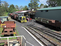
The 14 km long railway line that was to connect Kawakawa with Ōpua was built in sections in 1868 and completed to bispua in 1884 . It is the oldest railway line in New Zealand. After the line could no longer be used to transport coal, the Bay of Islands Vintage Railway Trust was formed in the late 1980s to revive the route as a museum railway line. 11.5 km of the original route have been restored. The museum trains, which run every Friday, Saturday and Sunday today and every day during school holidays and bank holidays, pass 14 bridges and an 80 m long tunnel.
Education
Kawakawa has an elementary school for grades 1 through 8, the Kawakawa Primary School and a college . The elementary school had a decile rating of 2 for 228 pupils in 2013 , which suggests a weak social structure in the area. The Bay of Islands College is a secondary school for grades 9 to 15 with 371 students in 2014 and also a decile rating of 2. The college accepts students from the Bay of Islands and the central Northland region . 85% of the students come to school by bus every day.
Attractions
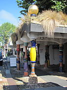
- The Hundertwasser toilet, a public toilet in the town's main street, was designed by Friedensreich Hundertwasser .
- Bay of Islands Vintage Railway
- Firefly caves in nearby Waiomio .
Personalities
- Friedensreich Hundertwasser (1928–2000), Austrian artist, lived in Kawakawa from 1973 until his death .
Photo gallery
See also
literature
- Helga Neubauer: Kawakawa . In: The New Zealand Book . NZ Visitor Publications , Nelson 2003, ISBN 1-877339-00-8 , pp. 108 f .
Web links
Individual evidence
- ↑ a b 2013 Census QuickStats about a place : Kawakawa . Statistics New Zealand , accessed August 25, 2014 .
- ^ Neubauer: Kawakawa . In: The New Zealand Book . 2003, p. 109 .
- ↑ a b Topo250 maps . Land Information New Zealand , accessed June 20, 2017 .
- ^ A b c Claudia Orange : Northland places - The Waiōmio valley - Kawakawa . In: Te Ara - the Encyclopedia of New Zealand . Ministry for Culture & Heritage , May 4, 2015, accessed June 20, 2017 .
- ↑ a b Our History . Bay of Islands Vintage Railway Trust , accessed June 20, 2017 .
- ^ Neubauer: Kawakawa . In: The New Zealand Book . 2003, p. 108 .
- ^ Train Timetable - Kawakawa to Taumarere . Bay of Islands Vintage Railway Trust , accessed June 20, 2017 .
- ^ Kawakawa Primary School . Te Kete Ipurangi ( TKI ), accessed December 1, 2015 .
- ^ Bay of Islands College . Te Kete Ipurangi ( TKI ), accessed December 1, 2015 .
- ^ School Information . Bay of Islands College , archived from the original on May 24, 2010 ; accessed on August 25, 2014 (English, original website no longer available).


