
Panoramic bike path Niederbergbahn
| Panoramic bike path Niederbergbahn | |
|---|---|
|
|
|
| overall length | 39.5 km |
| location | North Rhine-Westphalia |
| Starting point | Essen-Kettwig |
| Target point | Haan |
| Places along the way | Heiligenhaus , Velbert , Wülfrath , Wuppertal |
| Flooring | Asphalted |
| Height difference | rises from 45 m above sea level. NN at 260 m above sea level NN near Velbert |
| Traffic volume | 26 km of former railway line away from the roads |
| Connection to |
Ruhrtalradweg in Essen-Kettwig, Euroga-Radweg and Kaiser-Route in Wülfrath, Nordbahntrasse in Wuppertal, corkscrew route in Haan, |
| Website URL | www.panoramaradweg-niederbergbahn.de |
The Panoramaradweg Niederbergbahn (spelling: PanoramaRadweg Niederbergbahn ) is a cycle path established in 2011 mainly on the route of the disused Niederbergbahn .
The approximately 39.5 km long cycle path connects the Ruhr valley cycle path near Essen-Kettwig via Heiligenhaus , Velbert , Wülfrath , Wuppertal and Haan with the route of the corkscrew railway in Solingen . It uses the disused Niederbergbahn route for around 26 km. The connection at the north end to the Ruhr Valley Cycle Path is about 2 km long and almost flat on local roads. The 12 km long connection from the southern end of the railway line at the city limits of Wuppertal / Velbert to the corkscrew route leads with a few hills over farm roads in the upper Düsseldorf valley. The Niederbergbahn is a section of the 300 km long, supra-regional mountain panorama cycle path network. At Wülfrath there is also a connection to the Euroga cycle path and the Kaiser route . A connection to the Wuppertal Northern Railway is planned.
The opening took place on July 16, 2011 at the Wülfrath Time Tunnel with the participation of the then North Rhine-Westphalian Transport Minister Harry Voigtsberger , District Administrator of the Mettmann district Thomas Hendele , as well as the mayors of the cities of Heiligenhaus, Velbert, Wülfrath and Haan and the athlete Paul Meier .
The barrier-free expansion of the old railway line was carried out with an asphalt surface three meters wide. The cycle path, which is signposted throughout, uses 16 bridges and three large viaducts .
The cycle path was laid out, among other things, to secure the route of the railway line for long-term reactivation, e.g. B. as part of the Circle Line project .

Panoramic cycle path at the former Heiligenhaus train station

In the time tunnel
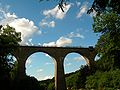
Over the Saubrücke


See also
- List of long-distance cycle routes in Germany
- Cycling network NRW
- List of cycle paths on disused railway lines
Individual evidence
- ↑ City of Velbert - Technische Betriebe Velbert AöR: PanoramaRadweg Niederbergbahn , accessed on June 24, 2012
- ↑ Achim Bartoschek; NW 4.03 PanoramaRadweg Niederbergbahn , accessed on June 24, 2012
Web links
- www.panoramaradweg-niederbergbahn.de
- ADFC Wuppertal
- Map of the northern part (PDF; 9.1 MB)
- Map of the southern part (PDF; 7.9 MB)
- WDR contribution to the panorama cycle path
- Photos and description Panoramaradweg
- A film worth seeing from the PanoramaRadweg Niederbergbahn
Coordinates: 51 ° 20 ′ 41.6 " N , 6 ° 55 ′ 29.3" E