
Papamoa Beach
| Papamoa Beach | ||
| Geographical location | ||
|
||
| Coordinates | 37 ° 42 ′ S , 176 ° 17 ′ E | |
| Region ISO | NZ-BOP | |
| Country |
|
|
| region | Bay of Plenty | |
| District | Tauranga City | |
| Ward | Mount Maunganui-Papamoa Ward | |
| Residents | 20th 094 (2013) | |
| height | 2 m | |
| Post Code | 3118, 3187 | |
| Telephone code | +64 (0) 7 | |
| website | www.papamoa.co.nz | |

Papamoa Beach is a district of Tauranga City in the Bay of Plenty region on the North Island of New Zealand .
geography
The district begins around 7 km east of the city center of Tauranga and stretches for around 16 km along the coast of the Bay of Plenty to the mouth of the Kaituana River in the Pacific Ocean . At its widest point, the district measures just under 2 km and at its narrowest point at the southeasternmost end only around 500 m. You can reach Papamoa Beach from the center of Tauranga over the New Zealand State Highway 2 and some streets of Mount Maunganui along the coast. From the south of Te Puke and south-east of Whakatāne , the district can also be reached via State Highway 2 .
history
Settlement of the coastal strip with a 40 m wide sandy beach and 160 m wide dune area began in the late 1980s. When the Tauranga Harbor Bridge was opened in 1988 , it was much faster and easier for the residents of Tauranga and holidaymakers from the greater Auckland area to get to the long beaches east of Mount Mauao . A year later, the coastal strip, the hinterland of which had been very rural until then, was incorporated into the city of Tauranga as far as the Kaituana River and continuously developed over the years. The result was exploding population in the district, as well as extremely rising land prices.
population
In the 2013 census, the district had 20,094 inhabitants, 20.6% more than in the 2006 census.
tourism
In addition to the Mount Maunganui district, Papamoa Beach is very popular with beach holidaymakers. Numerous apartments are mainly rented to vacationers or serve as vacation domiciles for people with a little money. The beach is one of the country's safe bathing beaches, where swimming, surfing, long beach walks and fishing are possible. Nude bathing is also possible between the signs on parts of the beach.
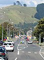
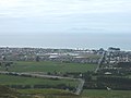
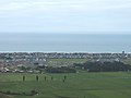
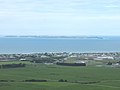
Photo gallery

Sandpiper (view to the southeast)

Mount Maunganui from Papamoa Beach seen from

Papamoa Beach from the Papamoa Domain
The Papamoa Hills from Domain Rd.

View to Mount Maunganui from the Papamoa Hills
View from the Papamoa Hills the Domain Rd. Down at Mayor Iceland
View of Papamoa from the Papamoa Hills
Parton Rd. And Motiti Island from the Papamoa Hills
.jpg)


Web links
- Papamoa New Zealand . Kiwiplanet New Zealand,accessed on January 10, 2015(English, localcommunitywebsite withnewsletterand advertising).
Individual evidence
- ↑ a b 2013 Census QuickStats about a place : Tauranga City . Statistics New Zealand , accessed on November 1, 2017 (English, StatsMap: Meshblock analysis from the interactive map, see: Pacific View, Palm Beach, Gravatt , Papamoa Beach East, Doncaster and Palm Springs ).
- ↑ a b Topo250 maps . Land Information New Zealand , accessed November 1, 2017 .
- ^ Tauranga Boundary Map . (PDF 323 kB) Tauranga City Council , archived from the original on January 14, 2015 ; accessed on May 7, 2019 (English, original website no longer available).
- ↑ Malcolm McKinnon : Bay of Plenty places - Mt Maunganui . In: Te Ara - the Encyclopedia of New Zealand . Ministry for Culture & Heritage , July 1, 2015, accessed November 1, 2017 .
- ↑ Papamoa Beach . Bay of Plenty Tourism , accessed November 1, 2017 .
- ↑ Hera Cook : Naturism - 'Bare on the beach' at Papamoa, 2012 - Mt Maunganui . In: Te Ara - the Encyclopedia of New Zealand . Ministry for Culture & Heritage , September 5, 2013, accessed November 1, 2017 .