Paraguaná
| Paraguaná | ||
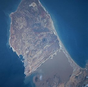
 Satellite image of the Paraguaná peninsula, the Gulf of Coro and the isthmus of Médanos |
||
| Geographical location | ||
|
|
||
| Coordinates | 12 ° 0 ′ N , 70 ° 0 ′ W | |
| Waters 1 | Gulf of Coro | |
| Waters 2 | Caribbean Sea | |
| length | 86 km | |
| width | 53 km | |
| surface | 3 405 km² | |
The Paraguaná peninsula is located in the northeast of the Venezuelan state of Falcón . It is known for its beaches and warm climate with little rainfall. The North Cape of Paraguanás, the Cabo de San Román , is also the northernmost point of the Venezuelan mainland. Only the island of Aves and the small island group Los Monjes are further north.
The Gulf of Coro almost separates the peninsula from the Venezuelan mainland. The isthmus of Médanos connects it with the city of Coro . The highest point on Paraguaná is Cerro Santa Ana . The island of Aruba lies off the coast in the north and the island of Curaçao , which belongs to the Netherlands Antilles , in the northeast .
The most important city on the peninsula is Punto Fijo . Administratively, the peninsula is divided into three municipalities : Carirubana , Los Taques and Falcón . About 350,000 people live on Paraguaná.
Paraguaná has been a completely free zone since 1998 . The Paraguaná oil refinery is of particular economic importance .
The church of San Nicolás de Moruy dates from the 18th century.
