Pasayten Wilderness
|
Pasayten Wilderness
|
||
|
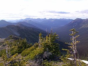
View from Slate Peak |
||
| location | Okanogan County / Whatcom County , Washington , USA | |
| surface | 2,151.06 km² | |
| WDPA ID | 372957 | |
| Geographical location | 48 ° 50 ′ N , 120 ° 40 ′ W | |
|
|
||
| Setup date | 2nd October 1968 | |
| administration | US Forest Service | |
The Pasayten Wilderness is a more than 2,100 square kilometer wilderness area in the United States , which is partly in the Okanogan National Forest , partly in the Mount Baker National Forest in the US state of Washington . The center is at 48 ° 54'2.1 "N / 120 ° 38'1.2" W at the Three Forks of the Pasayten River , a tributary of the Similkameen Riverspecified. Although part of it is in the Mount Baker-Snoqualmie National Forest, most of it is in the Okanogan National Forest, which is responsible for the management of the wilderness area. The area is bounded to the west by the Stephen Mather Wilderness . The northern border is the border between the United States and Canada . Across the border are Manning Provincial Park and Cathedral Provincial Park . The wilderness area is adjacent to the Ross Lake National Recreation Area to the west and beyond that to the North Cascades National Park . The northernmost section of the Pacific Crest Trail runs through this sanctuary. The western part of the area offers dramatic views and the peaks of the Cascade Mountains in northern Washington, while the eastern part is known for its meadows and alpine meadows . The highest point in the area is Jack Mountain ; the nearest cities are Mazama, Washington and Princeton, British Columbia .
The Pasayten wilderness is the traditional hunting ground of the Nlaka'pamux tribes of the Fraser Canyon and Nicola Country , although it is unclear which tribe is specifically referring to. This hunting area extended along the adjacent parts of the Cascade Range. However, there is no Nlaka'pamux on the US side of the border.
ecology
Rough ridges in the west merge into flat, open plateaus in the east; there are deeply buried drains on both sides. In the species-rich forests, the composition of the main tree species changes from fir , giant arborvitae and western hemlock in the west to fir, pine and larch in the east. The region provides habitats for deer , moose , mountain goats , pumas , bighorn sheep and wolves and is home to the largest population of the lynx in the Lower 48 .
Snow falls between October and May, and the densely packed snow can block the trails in the western part into early August. In the east, the trails are usually clear of snow in early July.
Hiking trails
Nearly a thousand kilometers (600 miles) of hiking trails provide access to the wilderness area. Many of them start deceptively gentle and become extremely difficult when reaching the heights due to the multiple turns. The Pacific Crest Trail (PCT) traverses the area from north to south for more than fifty kilometers (32 miles). The Boundary Trail starts in the southwest of the wilderness area and meanders north and west for nearly one hundred and twenty kilometers (73 miles) to the PCT near the Canadian border.
Some trails are used by riders who visit the wilderness area. Pets (horses) are used to support the transport of camping equipment as well as repair materials for the trails, because no motorized vehicles, not even wheeled equipment, can be used in the area.
Although the popular trails are cleared and maintained annually, it is important to point out that many trails are abandoned, closed or otherwise not maintained. Some of these trails are still marked on United States Forest Service maps of the area, while others are simply listed as unmarked connecting trails . Due to the lack of maintenance of the trails and the size of the area, some areas are rarely visited except by the most intrepid of individuals. For the general public, a good understanding of the use of maps and other navigational aids is recommended to further explore the wilderness area.
See also
Individual evidence
- ↑ a b c Pasayten Wilderness . In: Wilderness.net . University of Montana. Retrieved April 9, 2007.
- ↑ a b Pasayten Wilderness . In: Okanogan-Wenatchee National Forest . US Forest Service. Retrieved April 9, 2015.
Web links
- US Forest Service's Pasayten Wilderness website
- Pasayten Wilderness Wilderness.net (The University of Montana) (English)

