
Paulet Island
| Paulet Island | ||
|---|---|---|
 |
||
| Waters | Weddell Sea | |
| Archipelago | Joinville Islands ( West Antarctica ) | |
| Geographical location | 63 ° 34 ′ 47 ″ S , 55 ° 47 ′ 19 ″ W | |
|
||
| length | 2.2 km | |
| width | 1.5 km | |
| surface | 3.2 km² | |
| Highest elevation | 353 m | |
| Residents | uninhabited | |
 |
||

The Paulet Island ( English Paulet Island , French Île Paulet , Swedish Paulet Ø ) is a small, almost circular uninhabited volcanic island at the tip of the Antarctic Peninsula in the southern polar Weddell Sea .
geography
Paulet Island is 2.2 km long and a maximum of 1.5 km wide and is 5.2 km southeast of Dundee Island at the northeast end of the Antarctic Peninsula. The island consists of solidified lava , above which a 353 m high cinder cone with a small summit crater rises. With an age of a few hundred thousand years, the island is geologically very young. Geothermal energy ensures that parts of the island remain ice-free throughout the year. This warmth suggests that the volcano has been active for the past thousand years.
history
Paulet Island was discovered by a British expedition from 1839 to 1843 under James Clark Ross . This named the island as Paulet Island after the later admiral of the Royal Navy Lord George Paulet (1803-1879), son of the 13th Marquess of Winchester. In 1847 the island is listed as Île Paulet in the atlas of the French hydrograph Clément Adrien Vincendon-Dumoulin (1811-1858), in 1894 on Danish maps as Paulet Ø and in Germany from 1895 as Paulet Island .
The island was known mainly by the Swedish Antarctic Expedition of Otto Nordenskjöld , whose ship Antarctic at 25 miles away from the pack ice was destroyed and sank. After a 16-day hike across the ice, the crew around Captain Carl Anton Larsen reached the island on February 28, 1903, where the men built a stone hut and spent the winter. They were rescued nine months later by the Argentine corvette Uruguay . The ruins of the hut still stand today and are a popular destination for cruises to the Antarctic. As a historic HSM-41 site , it is protected by the Antarctic Treaty .
fauna
Paulet Island is home to around 200,000 Adelie penguins . In 2012, 548 breeding pairs of the blue-eyed shag were counted in the penguin colony . The island is also a breeding site for the snow storm and the Dominican gull . The frequently sighted here types snowy sheathbill and Wilson's Storm Petrel may also breed on the island. It is therefore designated by BirdLife International as an Important Bird Area (AQ066). Weddell seals and Antarctic fur seals regularly encamp on the island, while leopard seals are often seen hunting in the surrounding waters.
gallery
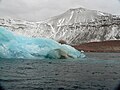
Paulet Island in February 2007
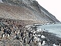
Adelie penguin colony on Paulet Island


Web links
- Paulet in the Global Volcanism Program of the Smithsonian Institution .
- Paulet Island in the United States Geological Survey's Geographic Names Information System .
- Paulet Island on geographic.org (English).
- Diedrich Fritzsche: Paulet Island (63 ° 35'S, 55 ° 47'W) - landscape in conflict of tourism with conservation of nature and historical monuments. Poster with further information on Paulet Island. Alfred Wegener Institute , Potsdam (English).
- Antarctic Voyage - January 23: Paulet Island. Photo report on Paulet Island. In: Air-and-Space.com. Brian Lockett (English).
Individual evidence
- ^ John L. Smellie et al .: The Cape Purvis volcano, Dundee Island (northern Antarctic Peninsula): late Pleistocene age, eruptive processes and implications for a glacial palaeoenvironment . In: Antarctic Science . tape 18 , no. 3 , September 2006, ISSN 0954-1020 , p. 399-408 , doi : 10.1017 / S0954102006000447 (English).
- ↑ Global Volcanism Program: Paulet (390041). In: Volcanoes of the World, v. 4.5.5. Edward Venzke, Smithsonian Institution , 2013, accessed April 9, 2017 .
- ^ John Stewart: Antarctica - An Encyclopedia . Vol. 2, McFarland & Co., Jefferson and London 2011, ISBN 978-0-7864-3590-6 , p. 1187 (English).
- ↑ HSM 41: Paulet Island Hut. In: ATS - Area Protection and Management / Monuments. Secretariat of the Antarctic Treaty, accessed April 9, 2017 .
- ↑ Paulet Island (AQ066) , datasheet on the BirdLife International website, accessed July 23, 2018.