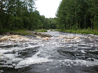
Perhonjoki
|
Perhonjoki Perho å |
||
| Data | ||
| Water code | FI : 49 | |
| location | Central Ostrobothnia , Österbotten ( Finland ) | |
| River system | Perhonjoki | |
| source | east of Perho 63 ° 10 ′ 37 ″ N , 24 ° 42 ′ 5 ″ E |
|
| Source height | approx. 200 m | |
| muzzle | north of Kokkola in the Gulf of Bothnia Coordinates: 63 ° 53 ′ 40 ″ N , 23 ° 8 ′ 16 ″ E 63 ° 53 ′ 40 ″ N , 23 ° 8 ′ 16 ″ E |
|
| Mouth height | 0 m | |
| Height difference | approx. 200 m | |
| Bottom slope | approx. 1.4 ‰ | |
| length | approx. 140 km | |
| Catchment area | 2,523.8 km² | |
| Right tributaries | Halsuanjoki | |
| Flowing lakes | Haapajärvi , Isojärvi | |
| Communities | Perho , Veteli , Kaustinen | |
The Perhonjoki ( Finnish ) ( Swedish Perho å ) is a river in the Finnish landscapes of Central Ostrobothnia and Ostrobothnia .
The river has its source east of the village of Perho in the Suomenselkä ridge . From there it flows first in a westerly, then in a northwest direction. It flows through Lake Haapajärvi , then takes in its largest tributary, the Halsuanjoki , and passes Veteli and Kaustinen . Further downstream, it flows through Lake Isojärvi and finally reaches the Gulf of Bothnia a few kilometers north of Kokkola . Its length is about 140 km, its catchment area covers 2524 km².
Individual evidence
- ↑ Finnish Ministry of the Environment - Suomen päävesistöalueet -taulukko ( Memento of the original from December 4, 2012 in the web archive archive.today ) Info: The archive link has been inserted automatically and has not yet been checked. Please check the original and archive link according to the instructions and then remove this notice.
