Muveran
| Grand Muveran | ||
|---|---|---|
|
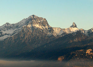
Grand Muveran (left) and Petit Muveran (right) of Torgon seen from |
||
| height | 3051 m above sea level M. | |
| location | Border canton Vaud / canton Wallis , Switzerland | |
| Mountains | Vaudois Alps | |
| Dominance | 8.8 km → Sommet des Diablerets | |
| Notch height | 1013 m ↓ Pas de Cheville | |
| Coordinates | 575 741 / 120588 | |
|
|
||
Muveran is the name for two striking mountain peaks in the Vaudois Alps in Switzerland that look very similar to one another from the north-west of the Rhone Valley . The peaks form the north-eastern continuation of the Dent de Morcles chain and are bounded in the south and west by the Rhône valley. The border between the cantons of Vaud and Valais runs over the mountain ridge .
The Grand Muveran reaches 3,051 m above sea level. M. , the Petit Muveran 2810 m above sea level. M. There are two small glaciers (Plan Névé) below the steep north flank of the Grand Muveran. South of the Grand Muveran is located at 2580 m above sea level. M. the Cabane Rambert of the Swiss Alpine Club SAC. From here, the Grand Muveran can be climbed via a high alpine path.
The Swiss painter Ferdinand Hodler made the painting “Le Grand Muveran” during a stay in Chesières in 1912 . In 2003 it was sold for 1,534,000 Swiss francs .
Tour des Muverans
The mountain range has been circled since 1989 by the Tour des Muverans high-altitude trail , which has a total length of around 50 kilometers. It runs clockwise from Lac de Derborence over the Col de la Forcla to Cabane Rambert, from which a detour to the peaks and the descent to Ovronnaz is possible. From there the path runs over the Col de Fénéstral to the Lacs de Fully and over the Col de Demècre to Rionda near Morcles and also goes around the Dent de Morcles . Then it runs along the Avançon river to Pont de Nant and over the Alpe Anzeinde and the Pas de Cheville back to the starting point at the lake. The tour is classified as a demanding mountain hike according to the SAC hiking scale .
Web links
- Muveran on the ETHorama platform
- Muveran on the ETHorama platform
- Grand and Petit Muveran: tour reports at hikr.org
- Tour des Muverans
Individual evidence
- ↑ a b National map of Switzerland
- ↑ Grand price for the Grand Muveran . In: swissinfo.ch, May 27, 2003. Retrieved January 28, 2012.
- ↑ Parcours ( Memento of the original from September 5, 2011 in the Internet Archive ) Info: The archive link was inserted automatically and has not yet been checked. Please check the original and archive link according to the instructions and then remove this notice. and map ( memento of the original from September 5, 2011 in the Internet Archive ) Info: The archive link was inserted automatically and has not yet been checked. Please check the original and archive link according to the instructions and then remove this notice. on tourdesmuverans.ch. Retrieved January 28, 2012
- ↑ Tour des Muverans on wandersite.ch. Retrieved June 28, 2012.


