Petruss
|
Petruss ( lb. Péitruss, French Pétrusse ) |
||
|
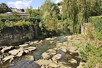
The renatured section of the Petruss shortly before its mouth |
||
| Data | ||
| location | Luxembourg | |
| River system | Rhine | |
| Drain over | Alzette → Sauer → Moselle → Rhine → North Sea | |
| source | In the corridor Aalheck 49 ° 36 '30 " N , 6 ° 1' 26" O |
|
| Source height | approx. 295 m | |
| muzzle | in the city of Luxembourg at Rue St. Ulric in the Alzette Coordinates: 49 ° 36 ′ 27 ″ N , 6 ° 8 ′ 14 ″ E 49 ° 36 ′ 27 ″ N , 6 ° 8 ′ 14 ″ E |
|
| Mouth height | approx. 246 m | |
| Height difference | approx. 49 m | |
| Bottom slope | approx. 3.8 ‰ | |
| length | 12.8 km | |
| Catchment area | 19.4 km² | |
The Petruss (Luxembourgish Péitruss, French Pétrusse ) is a nearly thirteen kilometers long, western and left tributary of the Alzette . It flows on its lower reaches through the city of Luxembourg .
Surname
The name comes from the Latin adjective petresa 'stony' (from petra 'stone'), because the bed of Petruss used to be covered with it. In 1933 it was moved to a concrete channel; In recent times, the last 50 meters to its mouth have been renatured as a stony river bed in order to be able to recreate the historical impression.
geography
Source area
On the eastern slope of the Dippecherbësch, a wooded elevation near Dippach , several spring streams arise at the same time, which soon flow together; with the inflow of the last, the Märelerbach, the Petruss then bears its name. The main hydrological strand rises at a height of 345 m.
course
The united Petruss first flows eastward through fields and meadows and then runs through the municipality of Bartringen . In Helfent it flows on the left side of the Aalbaach and immediately on the other side of the Grouf to.
It now crosses under the A 6 and then passes the municipal boundary from Bartringen to Luxembourg . It now runs along the southern edge of the Luxembourg district of Merl and then crosses the A 4 . At Hollerich , it is fed by the Zeissengerbach on the right side .
The Petruss now flows through the valley named after it and, after a little more than 12 kilometers, flows into the Alzette from the left in the Luxembourg district of Grund at an altitude of around 246 m .
Tributaries
- Aalbaach (left) , 1.9 km
- Grouf (right) , 6.7 km
- Zeissengerbach (right) , 7.4 km
Petrus Valley
The Petruss valley separates the upper town from the station district, which is also high up. The valley is spanned by two bridges, the Passerelle and the Adolphe Bridge , called "Al Bréck" (Old Bridge) and "Nei Bréck" (New Bridge) in the city. The Quirinus Chapel is located in the Petrus Valley .
Early regulations
In addition to the riverbed remains of the so-called are Bourbons - lock to recognize, which was built in 1728 in order to in case of attack to flood the city the valley.
Web links
- Course of the Petruss on the Geoportal Luxembourg - digital national map
- The Petrus Valley (PDF, 3.32 MB)

