Pfaffenberg (Eiserode)
| Pfaffenberg | ||
|---|---|---|
|
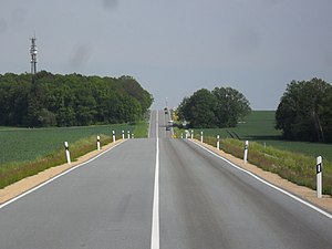
B 6 with Pfaffenberg coming from Hochkirch |
||
| height | 331 m | |
| location | Saxony , Germany | |
| Coordinates | 51 ° 7 ′ 41 ″ N , 14 ° 37 ′ 20 ″ E | |
|
|
||
| rock | Granodiorite | |
The Pfaffenberg ( Upper Sorbian Popica ) is a 331 meter high elevation in Eiserode , 4.5 kilometers northwest of Löbau in the district of Görlitz in Saxony .
The summit area of the mountain is slightly forested. It is crossed by federal highway 6 to the south, which here runs in three lanes in sections.
history
Its name apparently comes from former ownership when the northern part of the elevation belonged to Breitendorf and thus to the church of Kittlitz . The Upper Sorbian name is derived from pop = clergyman and is better known in the surrounding villages than his German name. In Löbau it is called Eiseroder Berg. It once separated the Löbauer from the Bautzener Land with a line from its once existing forest fringe from the mountain foot, over the Wohlaer Berg to the Strohmberg to Weißenberg .
Today there is a radio mast on it. The wood-free areas are used for agriculture.
Geography and flora
Above the granodiorite of the Pfaffenberg, which was quarried in several small quarries, lies gravel and stone-containing loam influenced by dammed earth. A weakly podsolized brown earth has developed on this. On the north and north-west slopes, remains of a mixed oak forest, rich in winter linden , are growing . At the foot of the slope, this changes to a woody stock rich in ash , and to a species-poor pedunculate oak-birch-aspen forest on waterlogged ground.
literature
- Between Strohmberg, Czorneboh and Kottmar (= values of our homeland . Volume 24). 1st edition. Akademie Verlag, Berlin 1974, p. 94.


