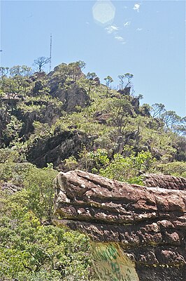
Pico dos Pireneus
| Pico dos Pireneus | ||
|---|---|---|
|
The highest mountain peak of the Serra dos Pireneus |
||
| height | 1394 m | |
| location | Brazilian mountain country in Goiás | |
| Mountains | Serra dos Pireneus | |
| Coordinates | 15 ° 47 '31 " S , 48 ° 50' 6" W | |
|
|
||
| rock | Quartzite | |
| Age of the rock | +1,000 mya | |
The Pico dos Pireneus (German: summit of the Pyrenees ) is located in the Pirieus State Park ( Pyrenees Mountains ) in the Brazilian state of Goiás between the municipalities of Cocalzinho de Goiás and Pirenópolis .
With a height of 1,394 m, it is the highest point in the region, from which u. a. the towns of Cocalzinho de Goiás, Corumbá de Goiás , Jaraguá , Edilândia , Abadiânia , Luziânia and Planalmira are visible, at night also the cities of Brasília , Anápolis and Goiânia . It is one of the main attractions in the park. At the top is the Santíssima Trindade ( Trinity ) chapel .
The Pico dos Pireneus consists of quartzite of sedimentary origin with an old age of more than a billion years ( Precambrian period ). On such a typical rock grows Cerrado - vegetation with a high degree of endemism .
Remarks
- ↑ Pireneus is sometimes also written Pirineus. You can also find the name Picos dos Pireneus / Pirineus, as three peaks are next to each other.
Web links
- Portal do Turismo de Pirenópolis , (Portuguese)
- José Oswaldo de Araújo filho, Universidade Federal do Paraná: Revista Brasileira de Geociências: Pirineus Syntaxis , (PDF, English)
Individual evidence
- ↑ Geoparques Pireneus , (Portuguese)

