Jaraguá
| Municipality of Jaraguá "Lendária Terra"
Jaraguá
|
|||
|---|---|---|---|
|
Igreja Nossa Senhora da Penha de Jaraguá
|
|||
|
|
|||
| Coordinates | 15 ° 45 ′ S , 49 ° 20 ′ W | ||
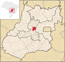
 Location of the municipality of Jaraguá in the state of Goiás Location of the municipality of Jaraguá in the state of Goiás
|
|||
| Symbols | |||
|
|||
| Basic data | |||
| Country | Brazil | ||
| State | Goiás | ||
| ISO 3166-2 | BR-GO | ||
| Região intermediária | Goiânia (since 2017) | ||
| Região imediata | Anápolis (since 2017) | ||
| height | 610 m | ||
| Waters | Rio das Almas | ||
| climate | tropical, Aw | ||
| surface | 1,849.6 km² | ||
| Residents | 41,870 (2010) | ||
| density | 22.6 Ew. / km² | ||
| estimate | 49,667 (July 1, 2018) | ||
| Parish code | IBGE : 5211800 | ||
| Time zone | UTC -3 | ||
| Website | jaragua.go (Brazilian Portuguese) | ||
| politics | |||
| City Prefect | Zilomar Antonio de Oliveira (2017-2020) | ||
| Political party | PSDB | ||
| Culture | |||
| City festival | July 26th (founding day) | ||
| economy | |||
| GDP | 636,212 thousand R $ 13,390 R $ per person (2016) |
||
| HDI | 0.699 (2010) | ||
Jaraguá , officially Portuguese Município de Jaraguá , is a Brazilian political municipality in the state of Goiás .
It is located west of the Brazilian capital Brasília and north of the capital Goiânia , from which it is 124 km away. According to the 2010 census, the population was 41,870, the population was estimated to have increased to 49,667 as of July 1, 2018, who live in a community area of around 1850 km² and are called Jaraguens. The area to be managed is around 70% of the Saarland.
Geographical location
Jaraguá borders on the municipalities:
- to the north at Rianápolis and Santa Isabel
- in the northeast with Goianésia
- to the east with Pirenópolis
- in the south to São Francisco de Goiás , Jesúpolis , Santa Rosa de Goiás and Taquaral de Goiás
- in the southwest at Itaguari
- to the west of Itaguaru
- in the northwest at Uruana
The municipal area is 55% flat, 35% hilly and 10% mountainous, the average altitude is 570 meters, the main town is at an altitude of 610 meters. The biome consists of cerrado and tropical forest.
Jaraguá is on the Brazilian federal highway BR-153 ( Brasília - Belém ).
Web link
- City Prefecture website , Prefeitura (Brazilian Portuguese)
- City Council website , Câmara Municipal (Brazilian Portuguese)
Individual evidence
- ↑ Jaraguá climate: average temperature, weather by month, Jaraguá weather averages. In: climate-data.org. Retrieved August 13, 2019 .
- ↑ a b c Jaraguá - Panorama. In: cidades.ibge.gov.br. IBGE , accessed August 13, 2019 (Brazilian Portuguese).
- ↑ Zilomar 45 (Prefeito). In: todapolitica.com. Eleições 2016, accessed August 13, 2019 (Brazilian Portuguese).
- ↑ Political map "GO_Politico.pdf" from Goiás ftp server of the IBGE (4.8 MB)


