Goianira
| Goianira | |
|---|---|
| coat of arms | flag |
| map | |
| Basic data | |
| State : |
|
| Administrative structure : | Midwest |
| State : |
|
| Mesoregion : | Central Goiás |
| Microregion : | Goiânia |
| Geographic location : | 16 ° 30 ′ S , 49 ° 26 ′ W |
| Distance to Goiânia : | 37 km |
| Time zone : |
UTC -3 summer : UTC-2 |
| Height : | 757 m |
| Area : | 200.402 km² |
| Residents : | 34,061 |
| Population density : | 170.0 inhabitants / km² |
| Telephone code : | +5562 |
| Post code ( CEP ): | 75370-000 |
| City administration address: | |
| Official Website: | |
| E-mail address: | |
| Anniversary: | |
| Church planting: | December 9, 1958 |
| politics | |
| Mayor : | |
| Vice Mayor: | |
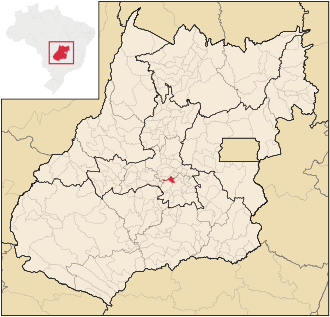
Goianira is a Brazilian political community in the state of Goiás in the mesoregion central Goiás and in the micro-region Goiânia . It is located southwest of the Brazilian capital Brasília and northwest of the capital Goiânia . The municipality belongs to the metropolitan area of Goiânia .
Geographical location
The community is adjacent
- in the north to the municipality of Inhumas
- in the northeast at Brazabrantes
- to the east on Santo Antônio de Goiás
- in the southeast at Goiânia
- in the southwest at Trindade
- in the northwest at Caturaí
Goianira is connected to Goiânia via the state road GO-070 , which in this part is designed with two lanes and separate directions.
The Meia Ponte River runs through the municipality .
See also
Individual evidence
- ↑ SEPLAN: Road kilometers to Goiânia ( Memento from February 5, 2009 in the Internet Archive )
- ↑ First results of the 2010 census in Goiás (PDF; 29 kB), carried out by IBGE .
- ↑ Região Metropolitana de Goiânia (PDF; 1.17 MB), study by Observatório das Metrópoles ( Memento of the original dated August 30, 2011 in the Internet Archive ) Info: The archive link was inserted automatically and has not yet been checked. Please check the original and archive link according to the instructions and then remove this notice.


