Cachoeira Alta
| Município d Cachoeira Alta Cachoeira Alta |
|||
|---|---|---|---|
|
|
|||
| Coordinates | 18 ° 46 ′ S , 50 ° 57 ′ W | ||
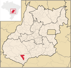
 Location of the municipality in the state of Goiás Location of the municipality in the state of Goiás
|
|||
| Symbols | |||
|
|||
| founding | 13th November 1953 (age 66) | ||
| Basic data | |||
| Country | Brazil | ||
| State | Goiás | ||
| ISO 3166-2 | BR-GO | ||
| structure | 1 multiple district | ||
| height | 497 m | ||
| climate | tropical, Aw | ||
| surface | 1,654.6 km² | ||
| Residents | 10,553 (2010) | ||
| density | 6.4 Ew. / km² | ||
| estimate | 12,484 (July 1, 2019) | ||
| Parish code | IBGE : 5204102 | ||
| Post Code | 75870-000 | ||
| Telephone code | (+55) 64 | ||
| Time zone | UTC −3 | ||
| Website | cachoeiraalta.go (Brazilian Portuguese) | ||
| politics | |||
| City Prefect | Kelson Souza Vilarinho (2017-2020) | ||
| Political party | Psd | ||
| economy | |||
| GDP | 241,275 thousand R $ 20,103 R $ per capita (2017) |
||
| HDI | 0.710 (high) (2010) | ||
Cachoeira Alta , officially Portuguese Município de Cachoeira Alta , German high waterfall , is a Brazilian municipality in the state of Goiás . It is located southwest of the Brazilian capital Brasília and the capital of the state of Goiânia . Cachoeira Alta is located in the extreme southwest of Goiás at an altitude of 483 to 497 meters above sea level on a plateau with a flat topography . The distance to the capital Goiânia is 356 km. The population was estimated as of July 1, 2019 at 12,484 inhabitants, who are called Cachoeira-Altensians ( cachoeira-altenses ) and live on a municipal area of around 1655 km².
In 1953 the municipality received city rights and was spun off from the municipality of Rio Verde , to which it had previously formed the Distrito de Cachoeira Alta since 1931 . The place is named after the stream of the same name. The municipality of São Sebastião also belongs to the municipality.
geography
Cachoeira Alta borders
- to the north to the municipality of Rio Verde
- in the northeast on Quirinópolis with the border rivers Rio Preto and Rio Alegre
- in the southeast at Paranaiguara
- from south to northwest at Caçu with the border river Rio CLaro
- in the northwest at Aparecida do Rio Doce with the border river Rio Doce
Cachoeira Alta is located on the diagonal BR-364 federal road , which connects São Paulo to Acre via the states of Minas Gerais , Goiás, Mato Grosso , Rondônia .
The biome consists of Brazilian cerrado and mata atlântica . The climate is tropical, Aw according to the Köppen and Geiger climate classification . The average temperature is 24.2 ° C. The average rainfall is 1521 mm per year.
Web links
- City Prefecture website , Prefeitura Municipal (Brazilian Portuguese)
- História de Cachoeira Alta (Brazilian Portuguese)
- City Council website , Câmara Municipal (Brazilian Portuguese)
Individual evidence
- ↑ a b c Cachoeira Alta - Panorama. IBGE , accessed July 23, 2020 (Brazilian Portuguese).
- ↑ SEPLAN: Road kilometers to Goiânia ( Memento from March 3, 2016 in the Internet Archive )
- ↑ Climate Cachoeira Alta: Weather, average temperature, weather forecast for Cachoeira Alta. In: de.climate-data.org. Retrieved July 23, 2020 .


