Luziânia
| Luziânia | |
|---|---|
| coat of arms | flag |
| map | |
| Basic data | |
| State : |
|
| Administrative structure : | Midwest |
| State : |
|
| Mesoregion : | East Goiás |
| Microregion : | Entorno de Brasília |
| Distance to Goiânia : | 187 km |
| Geographic location : | 16 ° 15 ′ S , 47 ° 57 ′ W |
| Time zone : | UTC -3; Summer : UTC-2 |
| Height : | 930 m |
| Area : | 3,961.536 km² |
| Residents : | 174,546 |
| Population density : | 44.1 inhabitants / km² |
| Telephone code : | +55 61 |
| Post code ( CEP ): | 72800-000 |
| Official Website: | luziania.go.gov.br |
| Church planting: | 1833 |
| politics | |
| Mayoress : | Edna Aparecida Alves dos Santos ( PROS ) |
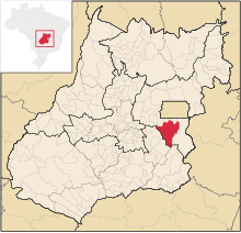
Luziânia is a Brazilian political municipality and city in the state of Goiás in the mesoregion East Goiás and in the micro-region Entorno de Brasília . It is located south of the Brazilian capital Brasília and west-northwest of the capital Goiânia .
Geographical location
Luziânia borders
- to the north at Novo Gama , Valparaíso de Goiás and Cidade Ocidental
- to the east to Cristalina
- to the south with Ipameri
- to the southwest on Orizona
- to the west at Leopoldo de Bulhões
- to the northwest at Alexânia and Santo Antônio do Descoberto
The distance to the capital Goiânia is 187 km on the federal road GO-010 via Vianópolis and Bonfinópolis . From Brasília the distance is 68 km.
See also
- Diocese of Luziânia
- Municipalities in the Entorno de Brasília microregion
- Mesoregions and micro-regions in Goiás
Web links
Commons : Luziânia - collection of images, videos and audio files
- City Prefecture website (Brazilian Portuguese)
- City Council website (Brazilian Portuguese)
Individual evidence
- ↑ SEPLAN: Road kilometers to Goiânia ( Memento from February 5, 2009 in the Internet Archive )
- ↑ Results of the 2010 census in Goiás (PDF; 30 kB), carried out by IBGE .


