Água Limpa
| Água Limpa | ||
|---|---|---|
|
Coordinates: 18 ° 4 ′ S , 48 ° 46 ′ W Água Limpa on the map of Brazil
|
||
| Basic data | ||
| Country |
|
|
| State |
|
|
| City foundation | 1958 | |
| Residents | 2012 (2010) | |
| City insignia | ||
| Detailed data | ||
| surface | 452.856 km 2 | |
| Population density | 4 people / km 2 | |
| height | 682 m | |
| prefix | +55 64 | |
| Time zone | UTC −3 | |
| Anniversary: November 11th | ||
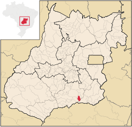
| Location of the municipality of Água Limpa in the state of Goiás | ||
Água Limpa (German Clean Water ; officially Portuguese Município de Água Limpa ) is a Brazilian municipality in the state of Goiás . It is located south-south-west of the Brazilian capital Brasília and 195 km south-south-east of the capital Goiânia near the southern border of Goiás and the state of Minas Gerais . As of July 1, 2019, the population was estimated to be 1850 inhabitants, who live on a community area of around 452.9 km².
Geographical location
Água Limpa borders
- to the north to the municipality of Rio Quente
- to the east with Marzagão
- from east to south at Corumbaíba (via the Rio-Corumbá branch of the Itumbiara reservoir )
- in the southwest on Buriti Alegre
- in the northwest at Morrinhos
See also
Web links
Individual evidence
- ↑ IBGE: History of Áqua Limpa (port .; PDF; 9 kB)
- ↑ Results of the 2010 census in Goiás (PDF; 29 kB), carried out by IBGE
- ↑ SEPLAN: Road kilometers to Goiânia ( Memento from February 5, 2009 in the Internet Archive )
- ↑ IBGE : Estimativas da população residente no Brasil e unidades da federação com data de referência em 1 ° de julho de 2019. (PDF) Retrieved on September 10, 2019 (Brazilian Portuguese).


