Aporé
| Aporé | |||
|---|---|---|---|
| coat of arms | flag | ||
| map | |||
|
|||
| Basic data | |||
| State : |
|
||
| Administrative structure : | Midwest | ||
| State : |
|
||
| Mesoregion : | South Goiás | ||
| Microregion : | Sudoeste de Goiás (GO) | ||
| Neighboring municipalities: | Serranópolis , Cassilândia - ( MS ), Itajá , Itarumã , Chapadão do Céu | ||
| Distance to Goiânia | 480 km | ||
| Geographic location : | 18 ° 58 ′ S , 51 ° 56 ′ W | ||
| Time zone : |
UTC -3 summer : UTC-2 |
||
| Height above d. M .: | 538 m above sea level NN | ||
| Area : | 2,900.344 km² | ||
| Residents : | 3.811 | ||
| Population density : | 1.3 inhabitants / km² | ||
| Telephone code : | +5564 | ||
| Post code ( CEP ): | 75825-000 | ||
| City administration address: |
Phone: |
||
| Official Website: | |||
| E-mail address: | |||
| Anniversary: | 14th November | ||
| Church planting: | 1958 | ||
| politics | |||
| mayor | |||
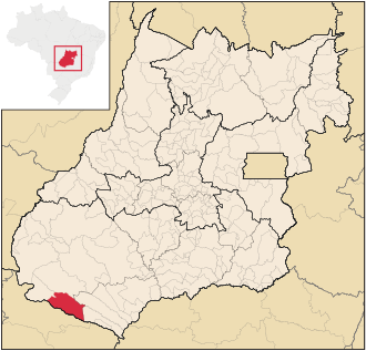
Aporé , officially Município de Aporé , is a Brazilian political municipality in the state of Goiás in the mesoregion South Goiás and in the microregion Sudoeste de Goiás . It is located southwest of the Brazilian capital Brasília and the capital Goiânia .
Other localities in the municipality are Córrego Fundo, Itumirim and Santa Lúcia.
location
Aporé borders the following municipalities:
- to the north with Serranópolis
- in the northeast at Itarumã
- in the southeast at Itajá
- in the southwest at Cassilândia - ( MS )
- in the northwest at Chapadão do Céu
The municipality lies between the rivers Rio Corrente and Rio Aporé (also called Rio do Peixe , the Aporé means river of fish ), both of which flow from northwest to southeast and flow as right tributaries into the Rio Paranaíba .
See also
Web links
- IBGE: History of Aporé , (PDF, Portuguese; 9 kB)
Individual evidence
- ↑ First results of the 2010 census in Goiás (PDF; 30 kB), carried out by IBGE .


