
Jussara (Goiás)
| Jussara | ||||
|---|---|---|---|---|
| coat of arms | flag | |||
 |
 |
|||
| map | ||||
|
||||
| Basic data | ||||
| State : |
|
|||
| Administrative structure : | Midwest | |||
| State : |
|
|||
| Mesoregion : | Northwest Goiás | |||
| Microregion : | Río Vermelho | |||
| Geographic location : | 15 ° 52 ′ S , 50 ° 52 ′ W | |||
| Distance to Goiânia : | 222 km | |||
| Time zone : |
UTC -3 summer : UTC-2 |
|||
| Height : | 317 m | |||
| Area : | 4,084 km² | |||
| Residents : | 19,153 | |||
| Population density : | 4.7 inhabitants / km² | |||
| Telephone code : | +5562 | |||
| Post code ( CEP ): | 76270-000 | |||
| City administration address: | Prefeitura Av. José Bonifácio, Nº726 Lt 1/3 |
|||
| Official Website: | www.jussara.go.gov.br | |||
| E-mail address: | [email protected] | |||
| Anniversary: | 14th November | |||
| Church planting: | 1958 | |||
| politics | ||||
| City Prefect : | Tatiana Ranna dos Santos ( PROS ), (2013-2016) | |||
| Vice City Prefect: | Clézio Ascêncio ( PT ), (2013-2016) | |||


.jpg)

Jussara , officially Município de Jussara , is a Brazilian political municipality and small town in the state of Goiás in the mesoregion of Northwest Goiás and in the microregion of Rio Vermelho . It is located west of the Brazilian capital Brasília and northwest of the capital Goiânia .
Cattle breeding , agriculture and milk production are primarily economically significant in Jussara . According to the 2010 census, the community had 19,153 inhabitants, the jussarianos . As of July 1, 2015, the IBGE estimated the population to be 19,346. The area is 4,084.114 km²; the population density is around five people per km².
Geographical location
Jussara borders in the northwest on the state of Mato Grosso (municipality of Araguaiana ) and then, clockwise, on the Goian municipalities of Britânia , Santa Fé de Goiás , Itapirapuã , Novo Brasil , Fazenda Nova and Montes Claros de Goiás .

From a hydrological point of view, Jussara belongs to the Amazon basin because of the two rivers Rio Tocantins and its left tributary Rio Araguaia .
Climate, geography and vegetation
The climate is typically tropical with high temperatures in summer around 30 ° C with a humidity of over 90% and heavy rainfall. In winter there is drought and drought lasting four to five months. Jussara is located in a southern branch of the Amazon basin, with the rivers Samambaia , Água Limpa , Rio Araguaia , Molha Biscoito and Palmeira . The vegetation is characterized by savannahs .
Population development

economy
| GDP data | |
| Agriculture: | 46,295 |
| Industry: | 13,386 |
| Service: | 93,839 |
| Subtotal: | 153,521 |
| Taxes: | 10,431 |
| PIB total: | 163,952 |
| Rank: | 62 |
| Population: | 18,814 |
| PIB per capita (R $): | 8,714 |
The table opposite shows the gross domestic product (GDP) in current prices for the three economic sectors , total PIB and rank of Jussara in Goiás, population and GDP per capita for 2007 (in thousands of R $ ). Agriculture has a high share of the economic output in Jussara, especially with cattle breeding (cattle, pigs, poultry) and milk production, while industry is only marginally represented by small businesses (such as a dairy).
Harvest yields in Jussara, 2008:
| Jussara |
Pineapple (piece) |
Cotton ( t ) |
Beans (t) |
Cassava (t) |
Rice (t) |
Soy (t) |
|---|---|---|---|---|---|---|
| 375,000 | 3,000 | 3,300 | 3,200 | 400 | 1,250 |
transport
In Jussara the federal road BR-070 (orientation: east-west) crosses with the state road GO-324 (orientation: north-south).
Distances:
- Goiânia: 231 km via Goiás via BR-070 and GO-070 or 222 km via Novo Brasil , Sanclerlândia , Anicuns , Trindade via GO-324/326/060
- Brasilia: 347 km via the BR-070
- São Paulo : 1191 km
- Rio de Janeiro : 1512 km
to the nearest larger cities:
- Itapirapuã , 28 km on the BR-070
- Goiás Velho , 86 km on the BR-070
- Iporá , 93 km via BR-070 and GO-324/326/173/060
- Barra do Garças ( MT ), 156 km on the BR-070
statistical data
| Human Development Index | ||||
|---|---|---|---|---|
| Jussara | Life expectancy HDI-A |
Education level HDI-B |
HDI-C purchasing power |
HDI |
| 1991 | 0.603 | 0.752 | 0.637 | 0.664 |
| 2000 | 0.718 | 0.836 | 0.667 | 0.74 |
| Increase from 1991 to 2000 | ||||
| Jussara | 19.1% | 11.2% | 4.7% | 11.5% |
| Goiás | 4.8% | 13.2% | 8.0% | 8.8% |
| Rank a) | 23 | 19th | 14th | 19th |
Rank within all 246 parishes of Goiás: |
104 | |||
Rank within all 5,507 Brazilian municipalities |
2145 | |||
|
a) : Rank of Goiás compared to all 26 states and the federal district.
|
||||
The table shows that the human development index developed better for Jussara with 11.5% in the years from 1991 to 2000 compared to Goiás with 8.8%. Life expectancy increased above average by 19.1% (to 68.1 years); Jussara is close to the average in education. However, the increase in purchasing power only reached around 60% of the average for Goiás, which roughly corresponds to the Brazilian average increase in this area (14th place).
In 2007, Jussara was one of the most competitive parishes in Goiás (57th place out of 246 parishes).
tourism
During the dry season from May to October, the almost exclusively Brazilian tourism is mainly concentrated on the extensive white sandy beaches of the Rio Araguaia, which marks the border between Goiás and Mato Grosso, as well as between Tocantins and Mato Grosso. The area around the Rio Araguaia is characterized by a very rich variety of animals and plants.
A popular weekend destination for locals is Lago Azul.
history
The first settlement was founded in 1945 by Estevam Fernandes Rebouças, Limírio Neves da Mota, Dionisio Candido da Silva and other pioneers who were looking for fertile land. They built their houses on the banks of the Água Limpa river (clean water, because of the clarity of the water) and baptized the village Colônia do Água Limpa. The fertility of the soil and the climatic conditions in the region encouraged the emergence of large and small agricultural and cattle farms. The Colônia do Água Limpa settlement expanded very quickly. The place name was changed to Juçara in 1950 (later to Jussara) in honor of Juçara Marques , who was elected Miss Brazil on June 12, 1949 as the first woman from Goiás .
Due to the rapid development and population growth, the Goiás Council raised Jussara to a district on September 12, 1953 by municipal law No. 138 by separating it from the Aruanã district and joining the Goiás Velho community.
By municipal law No. 2116 on November 14, 1958, the districts of Jussara, Juscelândia, Santa Fé and São Sebastião do Rio Claro were separated from Goiás and made the new municipality (Portuguese: município ) Jussara and directly under the jurisdiction of the government of the then Senator Dr . Subordinate to Pedro Ludovico . This date has been celebrated as the anniversary of Jussara ever since. The law came into force on January 1, 1959.
In October 3, 1960 the first local elections were held and Paulo Dias Toledo was elected as the first constitutional mayor.
On May 2, 1965, Jussara was raised to the category of an autonomous municipality, making it politically and administratively autonomous.
Since the territorial definition in 2003, the political municipality of Jussara has been made up of four localities (Portuguese: distritos ):
- Jussara
- Canadá
- Juscelândia
- Sao Sebastiao do Rio Claro
Other smaller villages / settlements are Canadasinho, Carajás, Comendador Marchesi, Betânia, Marechal Rondon, Campo Alegre, Mosquito, Vila Nova (counts as a district / sector of the small town Jussara, albeit a little to the west of it remote).
With the growth of the urban area, Jussara is now divided into sectors, namely: Bairro Araxá, Bairro Boa variety, Bairro Goiás, Bairro Nortista, Bairro Marajoara , Bairro São Francisco, Jardim Itaiara, Jardim Guanabara, Jardim Natalino, Jardim Petrópolis, Mansões dos Bosques , Nova Jussara, Recanto da Paz, Setor Aeroporto, Setor Alto da Boa Vista, Setor Central, Setor Cohab, Setor Comercial, Setor Marista, Setor Morada Nova, Setor Palmeiras, Setor Planalto, Vila Rebouças, Vila Santana, Setor Sonho Dourado, Vila Canaã, Vila Marajoara, Vila Mutirão, Vila Nova.
In Sector Aeroporto there is only one grass runway with an incline of approx. 10 °, which runs parallel to the GO-324 and is only suitable for small aircraft and only for use during the day. It is mainly used in medical emergencies.
photos
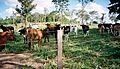
Cattle breeding on a small farm ( Chácara )

Butcher in Jussara

Market stall with live chickens
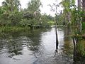
River "Água Limpa do Araguaia"


.jpg&filetimestamp=20091215204018&)

See also
Web links
- City Prefecture website (Portuguese)
- Website of the City Council (Câmara Municipal) (Portuguese)
- Jussara, GO. In: Atlas do Desenvolvimento Humano no Brasil , as of 2010 (Portuguese)
Remarks
- ↑ Spelling reference: Portugal and Brazil carried out spelling reforms for several decades, the Reforma ortográfica e nationalismo lingüístico no Brasil ( Memento of March 12, 2010 in the Internet Archive ), with the aim of a globally uniform orthography . One rule states that toponyms and all words with an indigenous origin, i.e. those from the Tupí-Guaraní languages , should be written with a cedilla (ç) instead of a double s . Juçara in Tupi-Guarani means "tree trunk". Palmeira juçara is a palm tree ( Euterpe edulis ), the spelling of which has changed over the years from yeï'sara to jiçara, jussara and finally juçara. However, the rule is largely ignored in Brazil.
Individual evidence
- ↑ SEPLAN: Road kilometers to Goiânia ( Memento of the original from February 5, 2009 in the Internet Archive ) Info: The archive link was inserted automatically and has not yet been checked. Please check the original and archive link according to the instructions and then remove this notice.
- ^ A b Instituto Brasileiro de Geografia e Estatística (IBGE): Cidades @ Goiás: Jussara. Retrieved September 22, 2015 (Portuguese).
- ↑ Eleições 2012 - Jussara / GO: Tatiana. eleicoes2012.info, accessed September 22, 2015 (Portuguese).
- ↑ Eleições 2012 - Jussara / GO: Clézio Ascêncio. eleicoes2012.info, accessed September 22, 2015 (Portuguese).
- ↑ River systems of South America
- ↑ PIB per municipality in Goiás ( Memento of the original from March 29, 2016 in the Internet Archive ) Info: The archive link was inserted automatically and has not yet been checked. Please check the original and archive link according to the instructions and then remove this notice. Source: SEPLAN 2007
- ↑ IBGE: Agricultural production 2008 by municipalities ( page no longer available , search in web archives ) Info: The link was automatically marked as defective. Please check the link according to the instructions and then remove this notice. (Portuguese)
- ↑ Distancias Rodoviarias Seplan ( Memento of the original dated February 5, 2009 in the Internet Archive ) Info: The archive link was inserted automatically and has not yet been checked. Please check the original and archive link according to the instructions and then remove this notice. (Portuguese)
- ↑ Distances according to the street map of Goiás, 2008 ( Memento of the original from December 17, 2011 in the Internet Archive ) Info: The archive link was inserted automatically and has not yet been checked. Please check the original and archive link according to the instructions and then remove this notice.
- ↑ Índice de Desenvolvimento Humano - Municipal, 1991 e 2000 ( Memento of the original from November 3, 2011 on WebCite ) Info: The archive link was automatically inserted and not yet checked. Please check the original and archive link according to the instructions and then remove this notice. for all Brazilian communities
- ↑ Índice de Desenvolvimento Humano Municipal (IDH-M) ( Page no longer available , search in web archives ) Info: The link was automatically marked as defective. Please check the link according to the instructions and then remove this notice. (PDF; 10 kB) For all Brazilian states
- ^ HDI for all parishes in Goiás, 2000
- ↑ SEPLAN (Secretaria de Planejamento e Desenvolvimento): Os demais municípios mais competitivos de Goiás ( Page no longer available , search in web archives ) Info: The link was automatically marked as defective. Please check the link according to the instructions and then remove this notice. (Portuguese; PDF; 433 kB)
- ↑ Juçara ou Jussara? ( Page no longer available , search in web archives ) Info: The link was automatically marked as defective. Please check the link according to the instructions and then remove this notice. (Portuguese)
- ↑ Photos from July 15, 1974 by Juçara Marques de Amorim with an enlarged article (Portuguese)
- ^ O concurso Miss Brasil 1949 (Portuguese).
- ↑ a b c IBGE: Cidades @ Goiás: Jussara Histórico. Retrieved September 22, 2015 (Portuguese; PDF; 10 kB).
Abadia de Goiás | Abadiânia | Acreúna | Adelândia | Água Fria de Goiás | Água Limpa | Águas Lindas de Goiás | Alexânia | Aloândia | Alto Horizonte | Alto Paraíso de Goiás | Alvorada do Norte | Amaralina | Americano do Brasil | Amorinópolis | Anápolis | Annexuera | Anicuns | Aparecida de Goiânia | Aparecida do Rio Doce | Aporé | Araçu | Aragarças | Aragoiânia | Araguapaz | Arenópolis | Aruanã | Aurilândia | Avelinópolis | Baliza | Barro Alto | Bela Vista de Goiás | Bom Jardim de Goiás | Bom Jesus de Goiás | Bonfinópolis | Bonópolis | Brazabrantes | Britânia | Buriti Alegre | Buriti de Goiás | Buritinópolis | Cabeceiras | Cachoeira Alta | Cachoeira de Goiás | Cachoeira Dourada | Caçu | Caiapônia | Caldas Novas | Caldazinha | Campestre de Goiás | Campinaçu | Campinorts | Campo Alegre de Goiás | Campo Limpo de Goiás | Campos Belos | Campos Verdes | Carmo do Rio Verde | Castelândia | Catalão | Caturaí | Cavalcante | Ceres | Cezarina | Chapadão do Céu | Cidade Ocidental | Cocalzinho de Goiás | Colinas do Sul | Córrego do Ouro | Corumbá de Goiás | Corumbaíba | Cristalina | Cristianópolis | Crixás | Cromínia | Cumari | Damianópolis | Damolândia | Davinópolis | Diorama | Divinópolis de Goiás | Doverlândia | Edealina | Edéia | Estrela do Norte | Faina | Fazenda Nova | Firminópolis | Flores de Goiás | Formosa | Gameleira de Goiás | Goianápolis | Goiandira | Goianésia | Goiânia | Goianira | Goiás Velho | Goiatuba | Gouvelândia | Guapó | Guaraíta | Guarani de Goiás | Guarinos | Heitoraí | Hidrolândia | Hidrolina | Iaciara | Inaciolândia | Indiara | Inhumas | Ipameri | Ipiranga de Goiás | Iporá | Israelândia | Itaberaí | Itaguari | Itaguaru | Itajá | Itapaci | Itapirapuã | Itapuranga | Itarumã | Itauçu | Itumbiara | Ivolândia | Jandaia | Jaraguá | Jataí | Jaupaci | Jesúpolis | Joviânia | Jussara | Lagoa Santa | Leopoldo de Bulhões | Luziânia | Mairipotaba | Mambaí | Mara Rosa | Marzagão | Matrinchã | Maurilândia | Mimoso de Goiás | Minaçu | Mineiros | Moiporá | Monte Alegre de Goiás | Montes Claros de Goiás | Montividiu | Montividiu do Norte | Morrinhos | Morro Agudo de Goiás | Mossâmedes | Mozarlândia | Mundo Novo | Mutunópolis | Nazario | Nerópolis | Niquelândia | Nova America | Nova Aurora | Nova Crixás | Nova Glória | Nova Iguaçu de Goiás | Nova Roma | Nova Veneza | Novo Brasil | Novo Gama | Novo Planalto | Orizona | Ouro Verde de Goiás | Ouvidor | Padre Bernardo | Palestina de Goiás | Palmeiras de Goiás | Palmelo | Palminópolis | Panamá | Paranaiguara | Paraúna | Perolândia | Petrolina de Goiás | Pilar de Goiás | Piracanjuba | Piranhas | Pirenópolis | Pires do Rio | Planaltina | Pontalina | Porangatu | Porteirão | Portelândia | Posse | Professor Jamil | Quirinópolis | Rialma | Rianápolis | Rio Quente | Rio Verde | Rubiataba | Sanclerlândia | Santa Bárbara de Goiás | Santa Cruz de Goiás | Santa Fe de Goiás | Santa Helena de Goiás | Santa Isabel | Santa Rita do Araguaia | Santa Rita do Novo Destino | Santa Rosa de Goiás | Santa Tereza de Goiás | Santa Terezinha de Goiás | Santo Antônio da Barra | Santo Antônio de Goiás | Santo Antônio do Descoberto | São Domingos | São Francisco de Goiás | São João d'Aliança | São João da Paraúna | São Luís de Montes Belos | São Luiz do Norte | São Miguel do Araguaia | São Miguel do Passa Quatro | São Patrício | São Simão | Senador Canedo | Serranópolis | Silvânia | Simolândia | Sítio d'Abadia | Taquaral de Goiás | Teresina de Goiás | Terezópolis de Goiás | Três Ranchos | Trindade | Trombas | Turvânia | Turvelândia | Uirapuru | Uruaçu | Uruana | Urutaí | Valparaíso de Goiás | Varjão | Vianópolis | Vicentinópolis | Vila Boa | Vila Propício