Porangatu
| Município de Porangatu Porangatu |
|||
|---|---|---|---|
|
|
|||
| Coordinates | 13 ° 26 ′ S , 49 ° 9 ′ W | ||
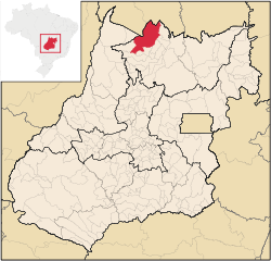
 Location of Porangatu in the state of Goiás Location of Porangatu in the state of Goiás
|
|||
| Symbols | |||
|
|||
| founding | August 25, 1948 | ||
| Basic data | |||
| Country | Brazil | ||
| State | Goiás | ||
| ISO 3166-2 | BR-GO | ||
| Região intermediária | Porangatu-Uruaçu (since 2017) | ||
| Região imediata | Porangatu (since 2017) | ||
| Mesoregion | Norte Goiano (1989-2017) | ||
| Microregion | Porangatu (1989-2017) | ||
| height | 405 m | ||
| Waters | Rio do Leite , Rio Santa Tereza, Rio Cana Brava, RioOuro Pintado, Rio Santa Maria, Rio Gregório and Lake Lagoa Grande | ||
| climate | tropical, Aw | ||
| surface | 4,820.5 km² | ||
| Residents | 42,355 (2010) | ||
| density | 8.8 Ew. / km² | ||
| estimate | 45,151 Ew. (July 1, 2018) | ||
| Parish code | IBGE : 5218003 | ||
| Post Code | 76550-000 to 76554-999 | ||
| Telephone code | (+55) 62 | ||
| Time zone | UTC −3 | ||
| Website | www.porangatu.go (Brazilian Portuguese) | ||
| politics | |||
| City Prefect | Pedro Joao Fernandes (2017-2020) | ||
| Political party | (PSDB) | ||
| economy | |||
| GDP | 832,622 thousand R $ 18,586 R $ per person (2015) |
||
| HDI | 0.727 (2010) | ||
Porangatu , officially Portuguese Município de Porangatu , is a medium- sized town in the north of the Brazilian state of Goiás . It is located in the ecoregion of the Cerrado . The distance to the capital Goiânia is 406 km.
According to the 2010 census, the municipality had 42,355 inhabitants, who are called Porangatuenser (Portuguese porangatuenses ) , on an area of 4820.5 km² . According to the IBGE's estimate of July 1, 2018, the population was growing to 45,151 . The population density is 8.8 people per km². It ranks 25th out of the 246 parishes of Goiás and 713th in Brazil.
Due to its convenient location on the BR-153 motorway from Belém to Brasília , which forms part of the Transbrasiliana here, the city is the most important city in the north of Goiás. A large part of the Brazilian agricultural trade is concentrated here and industrial production companies have settled here.
City administration
In the local elections in 2012, Eronildo Valadares of the Partido do Movimento Democrático Brasileiro (PMDB) was elected as city prefect for the term from 2013 to 2016 . In the local elections in Brazil in 2016, he was replaced by Pedro Joao Fernandes of the Partido da Social Democracia Brasileira (PSDB) for the term from 2017 to 2020.
The legislature lies with the Câmara Municipal, the city council of nine elected representatives.
Population development
Source IBGE (data for 2018 is only an estimate)

Web links
- City Prefecture website (Brazilian Portuguese)
- Câmara Municipal website (Brazilian Portuguese)
- IBGE: Goiás: Porangatu - História.
Individual evidence
- ↑ Porangatu climate: average temperature, weather by month, Porangatu weather averages. In: climate-data.org. de.climate-data.org, accessed on October 9, 2018 .
- ↑ a b IBGE : Cidades @ Goiás: Porangatu - Panorama. Retrieved October 9, 2018 (Brazilian Portuguese).
- ↑ a b c IBGE : Estimativas da população residente no Brasil e unidades da federação com data de referência em 1 ° de julho de 2018. (PDF; 2.6 MB) In: ibge.gov.br. 2018, accessed October 9, 2018 (Brazilian Portuguese).
- ↑ Pedro Fernandes 45 (Prefeito). In: com.br. Eleições 2016, accessed October 9, 2018 (Brazilian Portuguese).


