Turvânia
| Município de Turvânia Turvânia |
||
|---|---|---|
|
|
||
| Coordinates | 16 ° 36 ′ S , 50 ° 8 ′ W | |
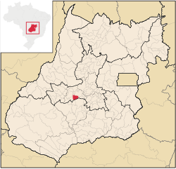
 Location of the Municip Turvânia in the state of Goiás Location of the Municip Turvânia in the state of Goiás
|
||
| founding | November 14, 1958 | |
| Basic data | ||
| Country | Brazil | |
| State | Goiás | |
| ISO 3166-2 | BR-GO | |
| Região intermediária | Região Geográfica Intermediária de São Luís de Montes Belos-Iporá (since 2017) | |
| Região imediata | Região Geográfica Imediata de Palmeiras de Goiás (since 2017) | |
| height | 659 m | |
| Waters | Córrego Poções | |
| climate | Aw | |
| surface | 480.8 km² | |
| Residents | 4839 (2010) | |
| density | 10.1 Ew. / km² | |
| estimate | 4633 (July 1, 2018) | |
| Parish code | IBGE : 5221502 | |
| Post Code | 76110-000 | |
| Time zone | UTC −3 | |
| Website | www.turvania.go.gov.br (Brazilian Portuguese) | |
| politics | ||
| City Prefect | Fausto Mariano da Silva (2017-2020) | |
| Political party | PMDB | |
| economy | ||
| GDP | 88,285 thousand R $ 18,252 R $ per capita (2016) |
|
| HDI | 0.697 (2010) | |
Turvânia , officially Portuguese Município de Turvânia , is a small Brazilian , political municipality in the state of Goiás with a large municipality. It is located west of the Brazilian capital Brasília and the capital Goiânia .
The place and its surrounding area originally formed the Distrito de Turvânia within the Munizips Anicuns and was spun off as an independent municipality by federal law No. 2.112 of November 14, 1958. According to an estimate by the IBGE, as of July 1, 2018, the community had 4633 inhabitants on a total area of around 481 km², which arithmetically results in a population density of less than 10 residents per km². The population is declining slightly after the last census in 2010.
Fernandópolis is also part of the Turvânia municipality. Fausto Mariano da Silva of the PMDB was named city prefect in the local elections in 2016 for the term 2017 to 2020 .
Geographical location
Turvânia borders
- in the north to the municipalities of São Luís de Montes Belos and Anicuns
- to the east at Nazário
- in the southeast at Palmeiras de Goiás
- to the south with Palminópolis
- to the west at Firminópolis
The climate is according to the Köppen and Geiger Aw climate classification , the average temperature is 24.1 ° C, the annual average amount of 1517 mm of precipitation.
Web links
- City Prefecture website , Prefeitura Municipal (Brazilian Portuguese)
- Instituto Brasileiro de Geografia e Estatística (IBGE): História. In: cidades.ibge.gov.br. Retrieved January 9, 2019 (Brazilian Portuguese).
Individual evidence
- ↑ a b Turvânia climate: average temperature, weather by month, Turvânia weather averages. In: climate-data.org. de.climate-data.org, accessed on January 9, 2019 .
- ↑ Instituto Brasileiro de Geografia e Estatística (IBGE): Turvânia - Panorama. In: cidades.ibge.gov.br. Retrieved January 9, 2019 (Brazilian Portuguese).
- ^ Fausto Mariano 15 (Prefeito). In: www.eleicoes2016.com.br. Eleições 2016, accessed January 9, 2019 (Brazilian Portuguese).
