Cavalcante (Goiás)
| Cavalcante | |||
|---|---|---|---|
| coat of arms | flag | ||
| map | |||
|
|||
| Basic data | |||
| State : |
|
||
| Administrative structure : | Midwest | ||
| State : |
|
||
| Mesoregion : | North Goiás | ||
| Microregion : | Chapada dos Veadeiros | ||
| Distance to the capital Goiânia : | 510 km | ||
| Geographic location : | 13 ° 48 ′ S , 47 ° 27 ′ W | ||
| Time zone : |
UTC -3 summer : UTC-2 |
||
| Height : | 823 m | ||
| Area : | 6,953.646 km² | ||
| Residents : | 9,394 | ||
| Population density : | 1.5 inhabitants / km² | ||
| Telephone code : | +5562 | ||
| Post code ( CEP ): | 73790-000 | ||
| City administration address: | Rua Cristã, 11 73790-000 Cavalcante |
||
| Official Website: | www.cavalcante.go.gov.br | ||
| E-mail address: | |||
| Anniversary: | November 11th | ||
| Church planting: | 1831 | ||
| politics | |||
| mayor | Josias Magalhães Costa Sobrinho ( PTN ), ( 2009 - 2012 ) | ||
| Vice Mayor | |||
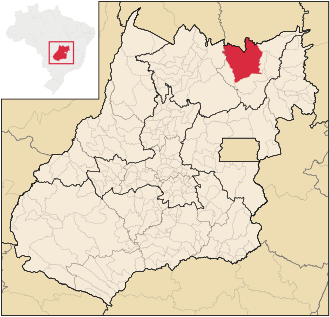
Cavalcante is a Brazilian political community in the state of Goiás in the mesoregion North Goiás and in the micro-region Chapada dos Veadeiros . It is located north of the Brazilian capital Brasília and northeast of the capital Goiânia .
Cavalcante to the districts include ( port. : Distrios ): Arai, Bonito, Estrema, Guaribinha, Passa Três, Prata and São Jose.
Geographical location
Cavalcante borders
- in the north to the mesoregion Oriental do Tocantins , TO
- in the northeast on Monte Alegre de Goiás
- on the east by Teresina de Goiás
- in the south at Alto Paraíso de Goiás
- in the southeast at Colinas do Sul
- in the northwest at Minaçu
Hydrographic location
Hydrographically, Cavalcante drains into the Rio Tocantins - Araguia basin to the north. Cavalcante is located east of the Serra da Mesa reservoir , the largest reservoir in Goiás in terms of water surface and storage volume. Its outflow is the Rio Tocantins , which forms the western border to the municipality of Minaçu. The municipal area is drained by the following bodies of water originating in the municipal area (arrangement according to confluence from south to north):
| River system | right tributaries | Drainage area | |
| Rio Tocantins | |||
| Rio Preto | Rio Claro | western municipal area | |
| Rio Sao Félix | |||
| Rio Carmo | |||
| Rio Trairas | |||
| Rio Paraná | left tributaries | eastern municipal area | |
| Rio das Almas | |||
| Rio da Prata | |||
Climate and vegetation
The climate is typically tropical and semi-humid with high temperatures in summer around 30 ° C with a humidity of 60 to 70% and heavy rainfall. In winter there is drought and drought lasting four to five months. The vegetation is characterized by Cerrado - ecosystem .
economy
|
Cavalcante (Goiás) GDP data (2007) |
|
| Agriculture: | 7,956 |
| Industry: | 27,288 |
| Service: | 93,839 |
| Subtotal: | 208,684 |
| Taxes: | 1,283 |
| PIB total: | 209.967 |
| Rank in GO: | 48 |
| Population: | 9,875 |
| PIB per capita (R $): | 21,262 |
| Rank in GO: | 15th |
The table opposite shows the gross domestic product (GDP) in current prices for the three economic sectors , total PIB and rank of Cavalcante in Goiás, population and GDP per capita for 2007 (in thousands of R $ ).
tourism
On the southern border to the municipality of Alto Paraíso de Goiás is the Chapada dos Veadeiros National Park , which is very popular with hikers and eco-tourists .
Access to the national park is only permitted with a guide. The entrance is in the village of São Jorge on the south side of the park, roughly halfway between the towns of Colinas do Sul and Alto Paraíso de Goiás .
See also
Web links
- Website of the municipality of Cavalcante (Goiás) (Portuguese)
Individual evidence
- ↑ First results of the 2010 census in Goiás (PDF; 30 kB), carried out by IBGE .
- ↑ PIB per municipality in Goiás ( Memento of the original from March 29, 2016 in the Internet Archive ) Info: The archive link was inserted automatically and has not yet been checked. Please check the original and archive link according to the instructions and then remove this notice. Source: SEPLAN 2007

