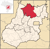
North Goiás mesoregion
| North Goiás mesoregion | |
|---|---|
| map | |
| Basic data | |
| State : |
|
| Administrative structure : | Midwest |
| State : |
|
| Mesoregion : | North Goiás |
| Microregions : |
Chapada dos Veadeiros |
| Number of municipalities: | 27 |
| Time zone : |
UTC -3 summer : UTC-2 |
| Area : | 56,509.394 km² |
| Residents : | |
| Population density : | |
The mesoregion North Goiás ( Portuguese Mesorregião do Norte Goiano ) was one of five internally geostatistical mesoregions of the Instituto Brasileiro de Geografia e Estatística (IBGE) from 1989 to 2017 for the Brazilian state of Goiás . It did not belong to the administrative units of Brazil and was replaced by another geostatistical regional division in 2017.
North Goiás bordered the state of Tocantins in the north , Bahia in the easternmost foothills and the mesoregions of East Goiás and Central Goiás in the south, and northwestern Goiás in the west . North Goiás comprises 27 municipalities (port: municípios ), which were allocated to two micro-regions :
In Niquelândia there is an open-cast mine owned by Anglo American , which has been mining nickel since 1982 .


